Forecast for the Logan Area Mountains

Toby Weed
Issued by Toby Weed on
Thursday morning, February 20, 2025
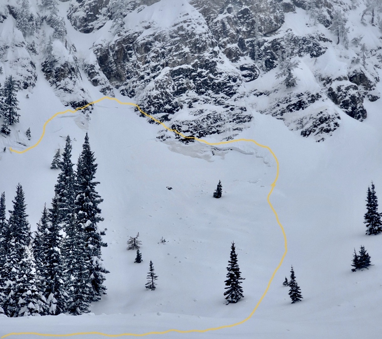
There is CONSIDERABLE avalanche danger at all elevations. People are likely to trigger dangerous avalanches on a persistent weak layer buried up to 3 feet deep, especially on previously drifted upper-elevation slopes facing northwest through southeast. Natural and human-triggered avalanches of storm snow are possible on slopes that picked up significant accumulations of new snow overnight, including on low-elevation slopes, where natural loose wet avalanches are possible during the day.
Careful snowpack evaluation, cautious route-finding, and conservative decision-making are essential for safe backcountry travel today.
Low
Moderate
Considerable
High
Extreme
Learn how to read the forecast here
Special Announcements
Help the University of Utah understand risk behavior in the backcountry by participating in a 15-minute survey. The U will compensate up to $30 for your time! Please note: responses will not be confidential but will be handled ethically under IRB guidelines.
Weather and Snow
The Logan area mountains picked up a few feet of snow in the last week, with the Tony Grove Snotel reporting over 7 inches of SWE (snow water equivalent) in only the last 7 days! There is 100 inches of snow with 118% of normal SWE for the date. Last night's storm favored Cache Valley and the front side of the Bear River Range, with more snow in my walkway than up at Franklin Basin. It looks like Cherry Peak got walloped with 10 inches on the lit snowstake.
Yesterday, we found generally snow stable conditions and finally enough snow to ski at lower elevations in the Logan Canyon area, with 1'-1.5' of recent snow capping a bomber dirty m/f crust from early February. The avalanche danger remains complex; dangerous in high drifted terrain, tons of new snow, and yet apparently stable snow and great powder riding down lower. Safe terrain choices are the best bet again today, so our plan is to stay on slopes less than 30° in slope steepness and out from under steep slopes where we suspect avalanches could occur.
You'll find excellent, DEEP powder riding conditions in the meadows, at lower elevations, and in safe, low-angle terrain.

-The Tony Grove Snotel at 8400 feet reports 2 inches of new snow with .4 inches of SWE in the last 12 hours. It's 25° F, with 100 inches of total snow. The Card Canyon weather station at 8800 feet reports 3 inches of new snow. It's 21° F, with 72 inches of total snow.
Winds on Logan Peak are blowing 13-20 mph from the west-northwest, and it's 18° F. At 9500 feet on Paris Peak it's also 18° F, with winds blowing 8 to 12 mph from the west-southwest.

Today snow is likely, and it may be heavy at times, with 3 to 5 inches of accumulation possible. Expect 8500' high temperatures around 26° F, and 6 to 10 mph winds from the west-southwest veering from the northwest during the day.
It looks like fair weather tomorrow and Saturday, with partly sunny skies and warming temperatures. We are concerned that the nice weather may influence people to make poor terrain choices.

Thank you for reading our forecasts before heading out into the backcountry - we've had four avalanche fatalities this season and do not want anyone else to die in an avalanche.

For more information, visit the UAC weather page here: Weather - Utah Avalanche Center
For Logan-specific weather, go here: Logan Mountain Weather - Utah Avalanche Center
Recent Avalanches
An observer reported very active avalanche conditions in the Bloomington Canyon area, with several natural and intentionally triggered avalanches on Monday and Tuesday, including a large natural that occurred when the party was in the vicinity Tuesday morning. HERE
Read about all avalanches and observations in the Logan Zone HERE.
Ad
Avalanche Problem #1
Wind Drifted Snow
Type
Location
Likelihood
Size
Description
People could trigger dangerous cornice falls and avalanches of previously drifted snow on many upper and mid-elevation slopes, but the danger is most acute on upper elevation slopes facing northwest through southeast. Natural cornice falls and large wind slab avalanches are possible as a tremendous amount of fresh snow has drifted into avalanche starting zones recently. Wind slab avalanches could step down to a persistent weak layer capping a dirty crust from early February.
  • Wind slabs are stiffer than surrounding snow, and they are smooth, rounded and chalky looking, and can sound hollow, like a drum when you move around on them. Today, wind slabs that were obvious yesterday could be hidden by a few inches of fresh snow.
  • Although most prevalent on the lee side of major ridges, stiff slabs of previously wind-drifted snow exist on all aspects in and around terrain features like sub-ridges, gullies, scoops, and cliff bands.
  • Cracking and whumpfs are sure signs of instability.
Avalanche Problem #2
New Snow
Type
Location
Likelihood
Size
Description
Soft slab and loose avalanches of storm snow are likely on steep slopes where significant new snow accumulated overnight. People are likely to trigger avalanches on slopes steeper than about 30°, and avalanches could be triggered remotely (from a distance) or from below steep slopes.
Wet avalanches are possible in lower-elevation terrain in the heat of the day, and people should stay out from under steep slopes as the fresh snow warms and gets sticky or saturated. Natural wet avalanches are possible in areas where people may not expect avalanches, like where you might walk the dog, throw a fly, or build a snowman.
Avalanche Problem #3
Persistent Weak Layer
Type
Location
Likelihood
Size
Description
Large and dangerous avalanches stepping down into older snow on one of several buried persistent weak layers are possible, especially in areas with shallower snow and poor snow structure. While we have not seen much recent activity on a PWL, sugary weak layers exist on slopes facing every direction, not just the northern half of the compass like we saw earlier in the season. One suspect layer is found right on top of a dirty melt-freeze crust from the warm spell at the beginning of February, others consist of crust-facet sandwiches. We've also been monitoring more deeply buried PWLs near the ground, which may produce large avalanches, especially in outlying terrain with shallow and generally weak snow.
  • Audible collapses (whumpfs) and shooting cracks are sure signs of instability, but these may not be present when avalanches occur.
  • Avalanches failing on a buried persistent weak layer might be triggered remotely (from a distance) or from below steep slopes.
Additional Information
This natural avalanche in the Bloomington Canyon area occurred Tuesday morning while the reporting party was recreating nearby. The avalanche stepped down to the dusty, early February crust.
General Announcements
-National Forest Winter Recreation Travel Maps show where it's open to ride: UWCNF Logan, Ogden LRD Tony Grove, Franklin Basin CTNF Montpelier
-For all questions on forecasts, education, Know Before You Go, events, online purchases, or fundraising, call 801-365-5522.
-Remember the information you provide could save lives, especially if you see or trigger an avalanche. To report an avalanche or submit an observation from the backcountry, go HERE.
-Receive forecast region-specific text message alerts to receive messages about changing avalanche conditions, watches, and warnings. Sign up and update your preferences HERE.

This forecast is from the U.S.D.A. Forest Service, which is solely responsible for its content. This forecast describes general avalanche conditions, and local variations always occur.