Forecast for the Logan Area Mountains

Issued by Toby Weed on
Sunday morning, February 19, 2023
Sunday morning, February 19, 2023
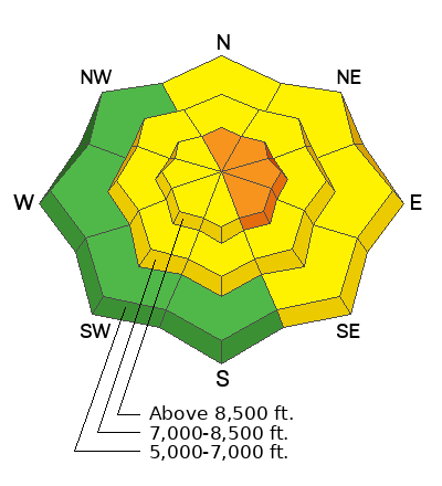
Last night's quick and blustery storm elevated avalanche conditions in the backcountry and there's MODERATE danger on drifted slopes at all elevations. People could trigger small wind slab or loose avalanches of storm snow on slopes steeper than 30°. Areas with more dangerous conditions and CONSIDERABLE danger may be found at upper elevations on drifted north through southeast facing slopes, where human triggered avalanches are likely.
- Evaluate snow and terrain carefully

Low
Moderate
Considerable
High
Extreme
Learn how to read the forecast here
 Weather and Snow
Last night's quick hitting storm elevated avalanche conditions, with several inches of snow and drifting. Winds from the west were sustained last night even as as snow was falling heavily, and people should avoid new drifts and realize that yesterday's hard wind slabs may be hidden by fresh powder. Shallow wind slab avalanches are possible today in exposed windy terrain, and they could be more likely and a bit larger at upper elevations. Looking ahead, last night's storm capped and preserved existing weak surface snow and widespread shallowly buried persistent weak layers.
The 8400' Tony Grove Snotel reports 7 inches of new snow, with .4" SWE. It's 18° F this morning, and there is 102 inches of total snow, with 125% of normal Snow Water Equivalent. The winds at the CSI weather station at 9700' on Logan Peak are from the west blowing around 25 mph.
Today: A 50 percent chance of snow before 11am. Mostly cloudy, with a high near 22. Wind chill values as low as -1. Breezy, with a west wind 14 to 23 mph, with gusts as high as 34 mph. Total daytime snow accumulation of 1 to 2 inches possible.
Tonight: A 30 percent chance of snow, mainly after 2am. Mostly cloudy, with a temperature rising to around 21 by 2am. Wind chill values as low as -3. Breezy, with a west wind 22 to 24 mph, with gusts as high as 37 mph. New snow accumulation of less than one inch possible.
Washington's Birthday: Snow. High near 26. Wind chill values as low as 5. Breezy, with a west wind 23 to 25 mph, with gusts as high as 38 mph. Chance of precipitation is 80%. New snow accumulation of 3 to 7 inches possible.
***A productive storm is developing for President's day and through much of next week, with significant accumulations possible, measured in feet, especially Tuesday and Tuesday night in the mountains of Utah and Idaho.
 Recent Avalanches
Avalanche Problem #1
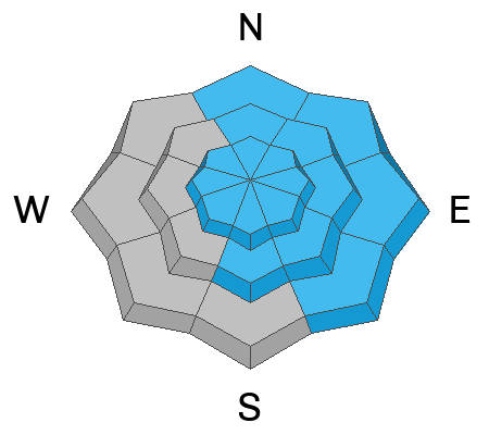
Wind Drifted Snow
Type
Location

Likelihood
Size
Description
- Avoid corniced slopes and stiffer drifts on steep slopes near ridges and in and around terrain features like cliff bands, sub-ridges, mid-slope break-overs, and gully walls.
- Wind slabs consist of stiffer drifted snow. Today, soft slab avalanches of drifted storm snow are most likely, but hard wind slabs also formed before the snow fell and some of these could still be sensitive to triggering.
- Hard wind slabs sometimes allow people to get out on them before releasing like a big mouse trap. They are often rounded and chalky looking and can make hollow, drum-like sounds.
- Some hard wind slabs are now hidden by last night's fresh powder
Avalanche Problem #2
New Snow
Type
Location

Likelihood
Size
Description
Small soft slab and loose avalanches of storm snow are possible in steep terrain. Even small avalanches of wind drifted or loose snow can be a problem, especially if you get carried into trees, gullies, benches, or rocks.
Additional Information
General Announcements
- Please submit your observations from the backcountry HERE.
- For a list of avalanche classes from the Utah Avalanche Center go HERE
- For information on where you can ride your sled or snowbike, check out this map of the winter travel plan for the Logan and Ogden Ranger Districts HERE, and a close up of the Tony Grove and Franklin Basin Areas HERE.
This forecast is from the U.S.D.A. Forest Service, which is solely responsible for its content. This forecast describes general avalanche conditions and local variations always occur.


