Check out our Holiday Auction

Forecast for the Logan Area Mountains

Trent Meisenheimer
Issued by Trent Meisenheimer on
Saturday morning, December 31, 2022
Today the avalanche danger is HIGH on all mid and upper-elevation steep slopes. People are likely to trigger an avalanche 1-4 feet deep on a persistent weak layer. Natural and human triggered avalanches involving slabs of new snow or wind-drifted snow are also very likely.
  • Very dangerous avalanche conditions. Traveling in avalanche terrain is not recommended.
  • Stay off and out from under backcountry slopes steeper than 30 degrees.
Low
Moderate
Considerable
High
Extreme
Learn how to read the forecast here
Avalanche Warning
What: The avalanche danger is expected to be HIGH.
When: In effect from 6 am MST Saturday morning to 6 am MST Monday
Where: For the mountains of northern and central Utah, including southeast Idaho. This includes the Wasatch Range, the Bear River Range, the Western Uintas, and the Manti-Skyline Plateau.
Impacts: Very dangerous avalanche conditions exist. With heavy snowfall and strong winds, both human-triggered and natural avalanches are likely. Stay off of and out from under slopes steeper than 30 degrees.
Weather and Snow
The winds picked up overnight and are blowing 35-40 mph gusting into the 70s on Logan Peak. It's snowing, and the mountain temperatures are hovering around freezing, with most weather stations reporting 29-32 °F temperatures. I would guess it's raining in the valleys and up to about 7,000' in elevation. In the past 24 hrs, the Logan Mountains have picked up 4-10 inches of new snow with (0.50"-1.40" water).
The Winter Storm Warning continues today, and we could see 6-12 inches of new snow throughout the day. Winds will continue to be blowing across the upper elevations. Temperatures will remain warmer today with a rain snow line that will ebb and flow around the 7,000' range for much of the day. We could see 15-32 inches of new snow by Sunday morning.
Recent Avalanches
On Thursday a backcountry observer noticed a large and destructive avalanche in White Pine Canyon. The avalanche was on a north-facing slope at 8,800' in elevation and was 3 feet deep and 150 feet wide, running to the valley floor.
Be sure to check out all observations HERE.
Ad
Avalanche Problem #1
Persistent Weak Layer
Type
Location
Likelihood
Size
Description
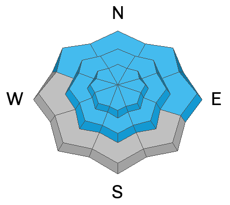
Persistent weak layers that formed back in November continue to plague many slopes. This weak layer is now buried 1-4 deep, and any avalanche that fails to this layer will likely be hundreds of feet wide and would likely be unsurvivable.
As we continue to load this weak layer today and through the weekend with heavy new storm snow (weight), I would give it the respect it deserves by avoiding slopes steeper than 30°. I would also avoid being below steep slopes as avalanches can run long distances.
The good news is the meadows and low-angle trees have excellent riding conditions, and there's no need to be on or underneath steep slopes to have fun.
Avalanche Problem #2
Wind Drifted Snow
Type
Location
Likelihood
Size
Description
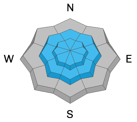
Winds are ripping on Logan Peak, averaging in the 30s and 40s mph, gusting into the 60s and 70s. With plenty of new snow to work with, the winds will only worsen the avalanche conditions by loading extra weight on slopes that are already unstable making it more dangerous.
Avalanche Problem #3
New Snow
Type
Location
Likelihood
Size
Description
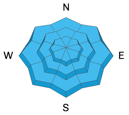
Even though snowfall rates don't pick up again until early evening, I would keep an eye out as the storm snow could become reactive during any period of heavier precipitation intensity. Cracking within the new snow is a tale tale sign of unstable snow. At elevations below about 7,000', it's likely to rain or a rain-snow mix.
Additional Information
General Announcements
Remember, when you leave the ski area boundary, Beaver Mt or Cherry Peak, you are entering the backcountry, and you could trigger dangerous avalanches.
As the end of the year approaches, please consider a donation to the UAC to support avalanche forecasting.
Please submit your observations from the backcountry HERE.
For a list of avalanche classes from the Utah Avalanche Center go HERE
For information on where you can ride your sled or snowbike, check out this map of the winter travel plan for the Tony Grove and Franklin Basin Areas HERE.
This forecast is from the U.S.D.A. Forest Service, which is solely responsible for its content. This forecast describes general avalanche conditions and local variations always occur.