Join us at our 2nd Annual Blizzard Ball

Forecast for the Logan Area Mountains

Toby Weed
Issued by Toby Weed on
Monday morning, December 30, 2024
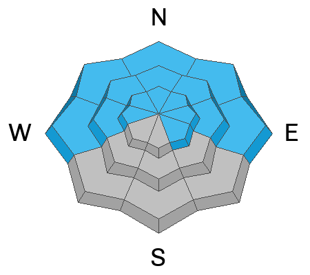
The avalanche danger is HIGH in the backcountry. Very heavy snowfall and drifting by strong winds overloaded slopes with pre-existing weak snow. Large and dangerous natural and human-triggered avalanches are likely, especially on northerly-facing slopes at mid and upper-elevations.
Very dangerous avalanche conditions exist, and people should avoid being on or beneath drifted slopes steeper than 30°. Stay well clear of obvious and historic avalanche paths and runout zones.
Low
Moderate
Considerable
High
Extreme
Learn how to read the forecast here
Avalanche Warning
What: The avalanche danger is HIGH.
Where: For the mountains of Northern Utah and Southeastern Idaho, including the Bear River Range, the Wasatch Range, and Wellsville Mountains.
Impacts: Heavy snowfall and strong winds have created widespread areas of unstable snow. Both human-triggered and natural avalanches are likely.
What to do: Avoid all avalanche terrain. Stay off of and out from under slopes steeper than 30 degrees. Carry and know how to use avalanche rescue equipment. Find safer riding conditions on slopes less than 30 degrees with no overhead hazard.
Special Announcements
Now is a great time to dial in your safety gear including putting fresh new batteries in your beacons! Local shops across the state will be handing out free Batteries for Beacons now until February 1, 2025. All you need to do is fill out a quick survey and grab the AAA or AA batteries you need to keep your beacon fresh this season. Find participating shops and more info HERE.
Weather and Snow
What a storm! While it rained in Cache Valley, the mountains in the Logan Zone were walloped with snow. The Tony Grove Snotel picked up 5.6 inches of SWE (snow water equivalent) since Christmas!
The heavy and dense snow is good for base building, but it's only worsened avalanche conditions. With widespread poor structure from earlier in the season, the mountain snowpack cannot adjust quickly to that much added weight, and large, destructive avalanches are likely. Much cooler temperatures today will start to set up the saturated snow down low, but where there is a remaining threat of overhead hazard, large natural avalanches are descending well into lower elevations. After all the rain, southerly low-elevation slopes are bare of snow or have only minimal snow cover.
People should avoid travel in all avalanche terrain. Stay off of and out from under slopes steeper than 30°, as avalanches can be triggered remotely (from a distance) or from below.
-The 8400' Tony Grove Snotel reports 1.2" of SWE in about 6 inches of heavy new snow in the last 24 hours. It's 20° F, with 59 inches of total snow.
-Winds on Logan Peak are blowing from the northwest 20 to 30 mph with gusts around 42 mph and it's 13° F.
-It's 16° F at 8800 feet at our Card Canyon station, with about 2.5 inches of new snow and 42 inches total.
-On Paris Peak at 9500 feet in Bloomington Canyon, it is 11° F and the winds are blowing 17 to 32 mph with 44 mph gusts from the west-northwest.

Temperatures in the mountains will be much cooler today, with 8500' temperatures dropping to around 15° F this morning. The winds will blow from the west-northwest 14-17 mph with gusts in the mid-30s. We may see a little light snow throughout the day, with less than an inch of accumulation expected. Tonight will be mostly cloudy, with temperatures dropping to around 8° F, 5 to 10 mph wind from the west-northwest, and wind chill values around zero. Tomorrow will be partly sunny, with a chance for a little snow as well. Expect high temperatures around 18° F and generally light winds blowing from the west-northwest.
A few inches of snow is likely to fall on New Years Day, and the weather pattern remains active through the weekend, with heavy snow possible Friday night and Saturday.

For more information, visit the UAC weather page here: Weather - Utah Avalanche Center
For Logan-specific weather, go here: Logan Mountain Weather - Utah Avalanche Center
Recent Avalanches
- On Christmas Eve, two local riders (brothers) had a close call with a large avalanche in Steep Hollow. The 2-foot-deep and 700-foot-wide avalanche occurred on a northeast-facing slope at around 9000 feet in elevation. The accident report is HERE.
- On Saturday, we remotely triggered an avalanche of drifted storm snow from a lower-angled adjacent slope, highlighting the fragile nature of the snowpack. Video HERE
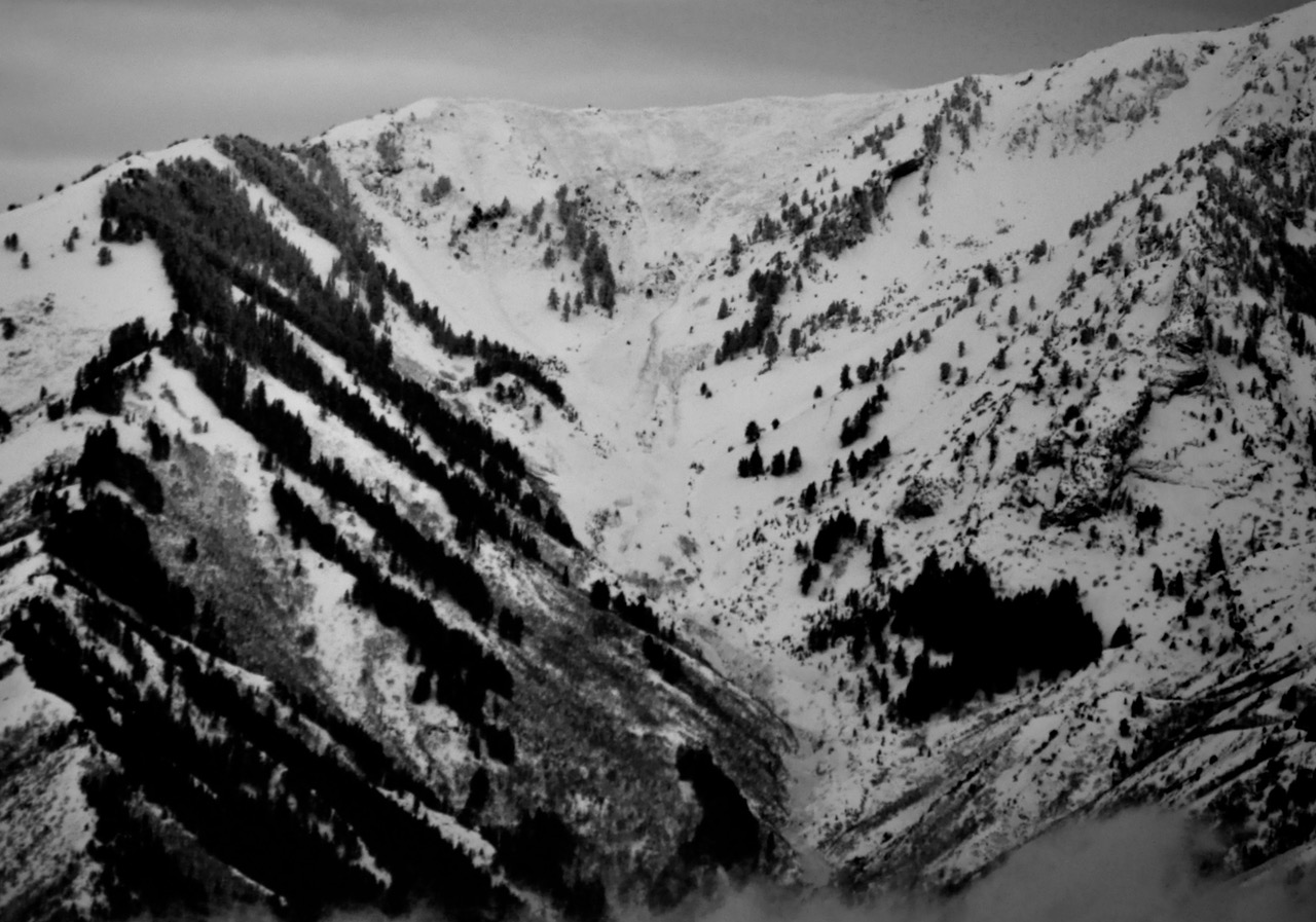
- Yesterday, In a short visibility window, I saw evidence of a widespread natural cycle in the Wellsville Mountain Wilderness. Large avalanches occurred in NE and E-facing terrain, some quite broad and long-running. One that caught my eye was in Pine Canyon, with a crown pushing 1/2 mile wide (estimate based on map measurement), running around 2500 vrt', and a large dirty (wet) debris pile spilling well into lower elevations. (photo below)
- You can read all recent local observations HERE.
Flat light, so sorry about the poor quality photo of the avalanche in Pine Canyon, taken from across the valley and 12 to 15 miles away.
Ad
Avalanche Problem #1
Persistent Weak Layer
Type
Location
Likelihood
Size
Description
Very weak faceted snow exists near the ground on almost all northerly-facing slopes at upper and mid-elevations. Other persistent weak layers have also been observed higher in the snowpack. Large and dangerous avalanches failing on the PWL are likely on drifted slopes steeper than 30°, and possible even in sheltered terrain.
  • Recent avalanches, shooting cracks, and collapsing (whumpfs) are signs of unstable snow but may not always be present.
  • Avalanches today could be triggered remotely (from a distance) or from below.
  • Large natural avalanches may still be likely today as the new heavy dense snow sits atop a buried layer of weak, sugary, faceted snow from earlier in the season.
Avalanche Problem #2
Wind Drifted Snow
Type
Location
Likelihood
Size
Description
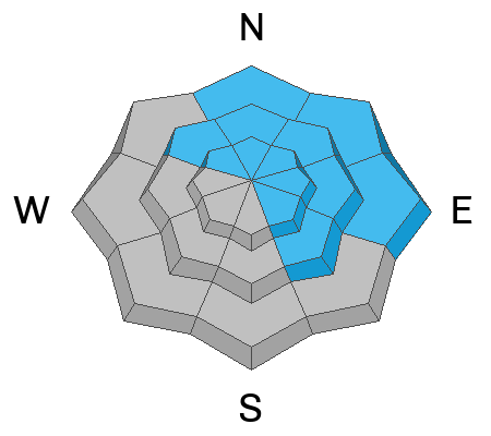
Winds have been cranking for days now, creating slabs of wind-drifted snow in exposed terrain. These drifts may allow you to get out onto them before releasing and may offer no signs of instability like cracking. freshly formed, thick, and heavy wind slabs slabs now overload slopes with poor snow structure.
  • Avalanches of wind-drifted snow are most likely on the lee side of major ridges.
  • Drifting has formed wind slabs in exposed terrain and in and around terrain features like cliff bands, sub-ridges, gullies, and scoops.
  • In some cases, wind slabs may be hanging in a delicate balance just waiting for a trigger. Larger avalanches stepping down to the widespread buried persistent weak layer are possible.
Avalanche Problem #3
New Snow
Type
Location
Likelihood
Size
Description
Heavy snowfall and rapid accumulations increased the danger of loose and soft slab avalanches at all elevations on snow-covered slopes steeper than 30°. Much colder temperatures today will set up the saturated snow at low elevations, reducing wet avalanche danger.
Additional Information
On Saturday, we remotely triggered a large avalanche south of Tony Grove Lake, above the campground.
General Announcements
-National Forest Winter Recreation Travel Maps show where it's open to ride: UWCNF Logan, Ogden LRD Tony Grove, Franklin Basin CTNF Montpelier
-Sign up for forecast region-specific text message alerts. You will receive messages about changing avalanche conditions, watches, and warnings...HERE.
-For all questions on forecasts, education, Know Before You Go, events, online purchases, or fundraising, call 801-365-5522.
-To report an avalanche or submit an observation from the backcountry, go HERE.
-Remember, even though the gate is still open, the Tony Grove Road is not maintained for winter driving.

This forecast is from the U.S.D.A. Forest Service, which is solely responsible for its content. This forecast describes general avalanche conditions, and local variations always occur.