Check out our Holiday Auction

Forecast for the Logan Area Mountains

Toby Weed
Issued by Toby Weed on
Wednesday morning, December 28, 2022
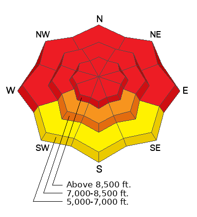
Heavy snow and drifting overloaded slopes with widespread buried persistent weak layers and created very dangerous avalanche conditions in the backcountry. HIGH avalanche danger exists at all elevations, with both dangerous human triggered and large and long running natural avalanches likely.
  • People should stay off and out from under backcountry slopes steeper than 30 degrees.
  • Avoid travel in avalanche terrain and stay clear of avalanche run-out zones.
Low
Moderate
Considerable
High
Extreme
Learn how to read the forecast here
Avalanche Warning
What: Heavy snow and drifting overloaded slopes with widespread buried persistent weak layers and created very dangerous avalanche conditions in the backcountry. HIGH avalanche danger exists at all elevations, with both dangerous human triggered and large and long running natural avalanches likely. People should stay off and out from under backcountry slopes steeper than 30 degrees.
When: In effect from 6am MST this morning to 6am MST Thursday
Where: For the Bear River Range of Northern Utah and Southeast Idaho.
Impacts: Heavy snow and drifting have created widespread areas of unstable snow. Both human triggered and natural avalanches are likely. Stay off of and out from under slopes steeper than 30 degrees.
Warning Times: Wednesday, December 28, 2022 - 6:00am to Thursday, December 29, 2022 - 6:00am
Special Announcements
As the end of the year approaches, please consider a donation to the UAC to support avalanche forecasting.
Didn’t get what you want for Christmas? Do your loved ones simply give you money for the holidays and say “Go buy something for yourself?” Support the UAC and get a great gift for yourself or your loved one at our Holiday Auction. The auction closes at 8:00 PM MT on January 2, 2023.
Weather and Snow
Lots of very heavy snow fell across the Logan Zone overnight, falling on widespread slopes with poor snow structure, slabs of previously wind drifted snow overlaying buried persistent weak layers buried 1 to 4 feet deep. Dangerous avalanches could be triggered remotely, from a distance or below. Large and long running natural avalanches are quite possible.
The Good News:
  • This storm is dumping a ton of very heavy wet snow, which is very good for our overall water situation.
  • Falling temperatures at lower elevations, which will set up the slushy snow and help snow stability.
  • Also, this is only the first round in a prolonged winter storm, and we could get lots more nice powder snow in the mountains before it's all done.

I'm reading a cool 23° F at the 8400' Tony Grove Snotel, and there is 15 inches of new snow in the last 24 hours with 2.1" of SWE. There is now 62 inches of total snow. Overnight the winds at the 9700' CSI Logan Peak weather station diminished a bit and veered from the northwest, now blowing 18 mph with gusts to around 35 mph.
Today, snowfall could be heavy at times, with 4 to 8 inches of additional accumulation possible and temperatures hovering in the lower 20s F. Winds generally blowing from the west-northwest at 15 to 20 mph are expected. Temperatures should drop to around 11° F tonight, with 3 to 5 more inches possible.
Maybe a bit of a break from snowfall tomorrow, but snow will continue to fall and accumulate in the mountains through the week and on into the new year...
Recent Avalanches
  • Rain melted significant lower elevation snow and spawned several natural wet avalanches running into the Logan River and off other steep lower elevation slopes across the zone on Tuesday.
  • A large avalanche was reported near Logan Peak, occurring around 12/23. It likely failed on facets.
  • ***See our updated list of observed avalanches from the Logan Zone HERE and from across Utah HERE
Ad
Avalanche Problem #1
Persistent Weak Layer
Type
Location
Likelihood
Size
Description
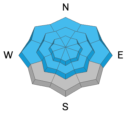
Persistent weak layers formed in November continue to plague many slopes, and last week's windy storm created a thick slab overlaying the weak layers, which created poor snow structure and an unstable snow situation in many areas.
There's a good chance a person can trigger a slab avalanche on a buried persistent weak layer of facets 1-4 feet deep. Where the snow is deepest like at upper elevations, this layer may be starting to gain some strength, but in areas with shallower snow, like low elevations or places scoured by winds, this widespread layer of loose sugary snow remains weak.
Mark rode throughout Copenhagen Basin Friday and found an unstable layer of surface hoar on top of these facets (video below). He thought he would have easily triggered a slide if he had tried to ride on a steep slope. The party experienced plenty of collapsing.
***Since we don't trust slopes with weak buried persistent weak layers, we'll continue to avoid avalanche terrain where it exists by staying off and out from under slopes steeper than 30°.
Avalanche Problem #2
New Snow
Type
Location
Likelihood
Size
Description
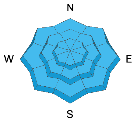
Soft slab and loose avalanches of new snow are likely on their own in steep terrain. Underlying persistent weak layers and poor snow structure aside, soft slabs of heavier storm snow could fail within the storm snow itself or on the old snow interface...
Additional Information
Take the all-new online avalanche courses the UAC built for Know Before You Go or take other online courses listed on the KBYG website (Develop skills -> Online Learning).
Remember, when you leave the ski area boundary, Beaver Mt or Cherry Peak, you are entering the backcountry, and you could trigger dangerous avalanches....
  • Put fresh batteries in your transceiver and inspect your shovel and probe.
  • Practice Companion Rescue with your backcountry partners.
General Announcements
As the end of the year approaches, please consider a donation to the UAC to support avalanche forecasting.
Please submit your observations from the backcountry HERE.
For a list of avalanche classes from the Utah Avalanche Center go HERE
For information on where you can ride your sled or snowbike, check out this map of the winter travel plan for the Tony Grove and Franklin Basin Areas HERE.
This forecast is from the U.S.D.A. Forest Service, which is solely responsible for its content. This forecast describes general avalanche conditions and local variations always occur.