Check out our Holiday Auction

Forecast for the Logan Area Mountains

Mark Staples
Issued by Mark Staples on
Thursday morning, December 23, 2021
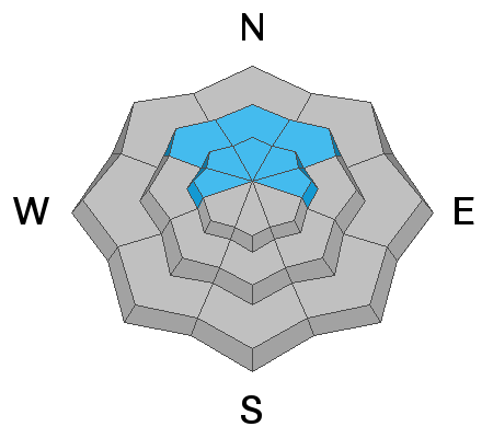
Heightened avalanche conditions exist at upper elevations on drifted north-facing slopes where a persistent weak layer near the ground can produce an avalanche. Winds have picked up some this morning at upper elevations and will be creating soft slabs of wind drifted snow. The danger is MODERATE on all upper elevations slopes and on mid-elevation, northerly-facing slopes, and people could still trigger dangerous avalanches remotely, from a distance, or from below. Slopes in sunny terrain and at lower elevations have less snow and a LOW danger. Expect the danger to rise rapidly and dangerous conditions to develop tonight as heavy snow and drifting from southwest winds overloads slopes with preexisting weak layers at all elevations.
  • Evaluate snow and terrain carefully.
Low
Moderate
Considerable
High
Extreme
Learn how to read the forecast here
Avalanche Watch
THE AVALANCHE DANGER IS EXPECTED TO RISE RAPIDLY TODAY.
AN AVALANCHE WATCH HAS BEEN ISSUED FOR THE MOUNTAINS OF MUCH OF THE STATE OF UTAH, INCLUDING THE WASATCH RANGE...BEAR RIVER RANGE...UINTA MOUNTAINS...MANTI-SKYLINE...AND THE ABAJOS.
HEAVY DENSE SNOWFALL AND STRONG WINDS WILL LIKELY CREATE VERY DANGEROUS AVALANCHE CONDITIONS. BOTH HUMAN TRIGGERED AND NATURAL AVALANCHES ARE LIKELY. STAY OFF OF AND OUT FROM UNDER SLOPES STEEPER THAN 30 DEGREES.
Weather and Snow
A Christmas winter storm will impact the region later today, and the national weather service has issued a Winter Storm Warning, with heavy snow likely in the mountains around Logan tonight through Christmas Morning. Two or three feet of snow could accumulate in favored locations in the Bear River Range. The much needed snow and drifting from sustained southwest winds will cause rapidly rising avalanche danger, and the storm is likely to create very dangerous avalanche conditions on many slopes in the backcountry. Light snow is expected to start falling today, west-southwest winds will blow 15 to 23 mph on the ridges, and it will be mostly cloudy with 8500' high temperatures around 32° F. Heavy snowfall is expected near the end of today.
The new snow will accumulate on weak sugary surface snow and/or feathery surface hoar or frost that formed in the last few days under high pressure weather conditions, and is widespread across the Logan Zone. In many areas the heavy new snow will not bond well to the weak surface snow, and avalanches of storm snow are likely. Once buried, the weak surface snow could become a tricky persistent weak layer. This type of weak snow can create avalanches on slopes less steep than you might expect. The storm will also overload a persistent weak layer near the ground on upper elevation north facing facing slopes, creating potential for very large and destructive avalanches.
Nice surface hoar feathers on the snow surface at low elevations in the backcountry. This can become a future persistent weak layer if it is buried intact.
Recent Avalanches
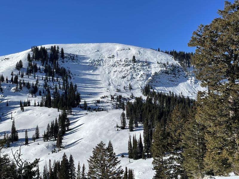
A pretty good sized natural avalanche of wind drifted snow was spotted yesterday off Providence Peak in upper Providence Canyon. Not really a surprise, as this very steep avalanche path frequently avalanches, especially with drifting from sustained southwest winds like we've seem in the past few days.

A couple skier triggered avalanches occurred Saturday in high north facing terrain. The largest was likely remotely triggered as it was observed near an uptrack near the Tony Grove-Blind Hollow Saddle at about 8800' on a north facing slope. The 2 to 3 foot deep avalanches failed on a persistent weak layer consisting of sugary faceted snow capping a crust near the ground.
Ad
Avalanche Problem #1
Persistent Weak Layer
Type
Location
Likelihood
Size
Description
A buried persistent weak layer consisting of sugary faceted snow lurks near the ground in some upper elevation north facing terrain. At upper elevations the old snow from October and early November is capped by a hard icy rain/rime crust. On some slopes a thin layer of small facets exists above this crust, the December snow is not well bonded to it, and local several avalanches in the Logan Zone failed on this weak layer.
  • People reported triggering audible collapses or "whumpfs" in the backcountry last weekend. These heart-stopping booming noises indicate unstable snow and potential for dangerous avalanches failing on a persistent weak layer.
  • Collapses are often accompanied by shooting cracks in the snow surface. Recently, we've seen some of these extend quite a distance away from where the collapse was triggered. Extensive cracking like this is a sure sign of instability, meaning people could easily trigger avalanches on steeper slopes.
Additional Information
  • Always follow safe backcountry travel protocols. Go one person at a time in avalanche terrain, while the rest of your party watches from a safe area.
  • Check your avalanche rescue equipment, change your batteries, and practice often with your backcountry partners.
  • Be very careful, keep your speed down, and stay in control. Encounters with shallowly buried rocks or down trees in the early season have led to many season-ending injuries.
  • The gate at the bottom of the Tony Grove Road was closed yesterday to preserve snow on the road for grooming.
General Announcements
Who's up for some free avalanche training? Get a refresher, become better prepared for an upcoming avalanche class, or just boost your skills. Go to https://learn.kbyg.org/ and scroll down to Step 2 for a series of interactive online avalanche courses produced by the UAC.
  • Check out all the upcoming education classes and clinics HERE.
  • Please submit your observations from the backcountry HERE.