Check out our Holiday Auction

Forecast for the Logan Area Mountains

Toby Weed
Issued by Toby Weed on
Friday morning, December 10, 2021
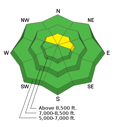
Heavy snowfall this morning and drifting snow will cause increasing avalanche danger today. The danger is MODERATE, heightened conditions exist, and avalanches of drifted new snow are possible at upper elevations on slopes facing northwest, north, northeast, and east. People could trigger avalanches where westerly winds deposited stiffer drifts or wind slabs on steep slopes in exposed terrain.
  • Remember to always follow safe travel protocols. Go one person at a time in avalanche terrain, while the rest of your party watches from a safe area.
  • Check your avalanche rescue equipment, change your batteries, and practice often with your backcountry partners.
Low
Moderate
Considerable
High
Extreme
Learn how to read the forecast here
Special Announcements
Get free batteries for your transceiver and a chance to win 1 of 10 Black Diamond Rescue Kits, 1 of 3 Mammut Barryvox transceivers, or 1 of 3 BCA Tracker transceivers. Stop at a participating shop, fill out our survey and get a free set of batteries. Don't need batteries, but still want a chance to win? Simply fill out the survey to be registered. Promotion runs through December 19.
  • Check out all the upcoming education classes and clinics HERE.
  • Please submit your observations from the backcountry HERE.
Weather and Snow
Finally, snow is falling in the Bear River Range, with around 7 inches of accumulation from the storm on upper elevation slopes in the Logan Zone. Mountain snow will continue today , with 3 to 7 inches of additional accumulation possible on upper elevation slopes by this evening. Increasing west-northwest winds will drift the new snow at upper elevations creating stiffer wind slabs, and people could trigger avalanches on steep slopes.
At the highest elevations in the Logan Zone, the new snow is stacking up on few inches of loose sugary faceted snow capping a very hard rain-crust from mid November. Sunny slopes up high and most terrain at mid and lower elevations were still bare of snow before the storm....
Recent Avalanches
Yesterday skiers triggered a few small loose avalanches of new snow or sluffs in steep terrain in the Central Bear River Range. No other avalanches were reported.
Ad
Avalanche Problem #1
Wind Drifted Snow
Type
Location
Likelihood
Size
Description
  • People could trigger small avalanches at upper elevations, especially in exposed terrain where winds are creating drifts.
  • A sure sign of unstable snow is apparent if you trigger shooting cracks or initiate cracking in the snow surface.
  • ​​​​​​As is usual during periods of dry weather, the old snow surface became quite varied across terrain. In shady, or mostly north facing areas up high, a hard rain-crust dominates the shallow snowpack structure. In some areas this is likely to be a problem, a smooth and slick bed surface with a couple inches of very loose sugary snow on top of it.
  • Avalanches might run further and faster than expected, and could be dangerous due to very shallow snow conditions.
Additional Information
  • Be very careful, keep your speed down, and stay in control. Encounters with shallowly buried rocks or down trees in the early season have led to many season-ending injuries.
  • The Tony Grove Road is not maintained for wheeled vehicles in the winter season.