Forecast for the Logan Area Mountains

Issued by Paige Pagnucco on
Sunday morning, January 5, 2025
Sunday morning, January 5, 2025
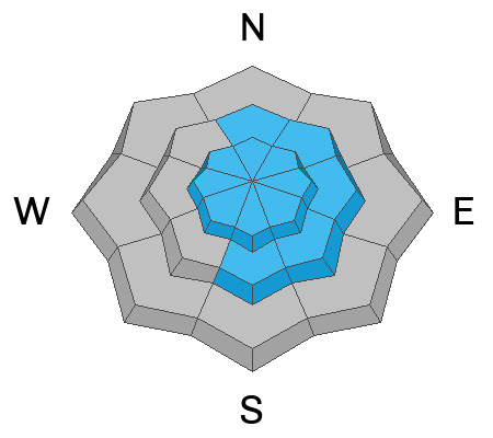
The avalanche danger is CONSIDERABLE today. Natural avalanches are possible, and human-triggered avalanches are likely in mid- and upper-elevation terrain on slopes steeper than 30°. On slopes that hold poor snowpack structure, avalanches could be triggered remotely (from a distance) or from below.
- Travel advice: Avoid traveling in avalanche terrain. Good riding conditions are found in meadows and on slopes less than 30 degrees.

Low
Moderate
Considerable
High
Extreme
Learn how to read the forecast here
 Weather and Snow
It finally looks like winter, with a bit of snow in the valley and a fresh coat of white in the mountains. Yesterday's storm didn't deliver as much as expected, but the Logan Peak area and the Wellsvilles seemed to be the big winners, with reports of up to a foot of fresh snow in places. With poor snowpack structure still a major concern, human-triggered avalanches are likely on many northerly-facing slopes at mid and upper elevations, especially where the wind has loaded starting zones. Avoid steep slopes with freshly wind-drifted snow. You'll find good shallow powder riding conditions in sheltered, shaded, low-angle terrain not connected to steep terrain. The snow is mostly supportable, and all the rocks, stumps, and downed trees are almost covered above about 8500', especially in the northern and central parts of the Bear River Range.
We are staying out of avalanche terrain this weekend.
-The 8400' Tony Grove Snotel reports 6" of new snow from yesterday with .5 SWE. It's 21° F, with 62 inches of total snow.
-Winds on Logan Peak ( 9700') are blowing from the northwest around 18 mph, with gusts in the 30's mph and it's 14° F.
-It's 17° F at 8800' at our Card Canyon station, with 46 inches of total snow.
-On Paris Peak at 9500' in Bloomington Canyon, it is 14° F, and westerly winds are blowing 18 mph with gusts of 20 to 30 mph.
Snowfall continues today and the Bear River Range will see the best shot at accumulating snow, generally 1 to 3 inches, but locally, up to 6 inches near Tony Grove. This should help improve riding conditions but will keep us off of steep slopes. Bundle up today - it'll feel like winter with a high of 23° F and wind chill near 7° F. Winds will blow from the west 10-20 mph. Light snow continues through tomorrow before we clear out and get some sunshine and calm weather midweek.
For more information, visit the UAC weather page here: Weather - Utah Avalanche Center
For Logan-specific weather, go here: Logan Mountain Weather - Utah Avalanche Center
 Recent Avalanches
We've completed the Davenport Hill and Porter Fork accident reports. Our condolences go out to the victims' families and friends and all those affected by these tragic accidents.
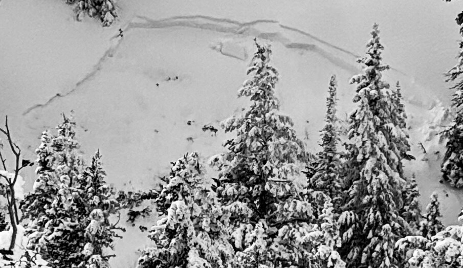
An observer sent in this recent avalanche from upper Providence Canyon.

We are still getting reports of avalanches from last weekend's cycle.
You can read all recent local observations HERE.
Avalanche Problem #1
Persistent Weak Layer
Type
Location

Likelihood
Size
Description
Very weak faceted snow exists near the ground on almost all northerly-facing slopes at upper and mid-elevations. While definitive signs of instability like collapsing are waning, the poor snowpack structure hasn't gone anywhere. It is still our top concern and not to be trifled with. Eventually it will be buried deeply enough to not pose a problem but we are not there just yet. We need to give these slopes more time to heal. The list of popular slopes that have yet to avalanche includes the Rodeo and Fairgrounds Bowls on the east side of Logan Peak, 3-Terraces, and the north face of Providence Peak, the east face of Mt Magog, Double Top, as well as Wilderness Peak, St. Charles, Slide Canyon, and many more.....
- Recent avalanches, shooting cracks, and collapsing (whumpfs) are signs of unstable snow, but these obvious signs of instability will not always be present when a large avalanche occurs.
- Avalanches could be triggered remotely (from a distance) or worse, from below steep slopes in the flats.

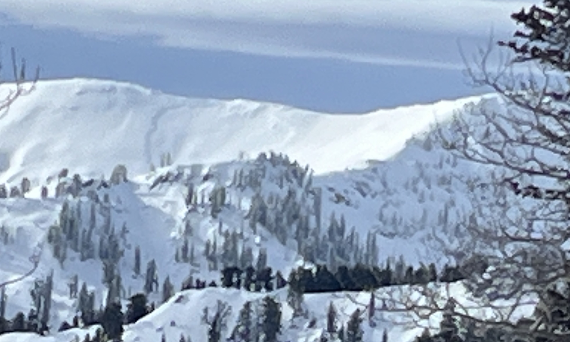
A large natural avalanche on Cornice Ridge that likely occurred in the overnight hours of 12/28-12/29. It got filled back in with snow but likely failed on the PWL.
Avalanche Problem #2
Wind Drifted Snow
Type
Location

Likelihood
Size
Description
Drifting has created soft and hard slabs of wind-drifted snow in exposed terrain, which may fail due to poor snowpack structure or at the old/new snow interface.
- Avalanches of wind-drifted snow are most likely on the lee side of major ridges.
- Drifting has formed new wind slabs in exposed terrain and in and around terrain features like cliff bands, sub-ridges, gullies, and scoops.
- Soft wind slabs may be quite sensitive, and some may be remotely triggered. Stiff wind slabs may allow you to get out onto them before releasing.
General Announcements
-National Forest Winter Recreation Travel Maps show where it's open to ride: UWCNF Logan, Ogden LRD Tony Grove, Franklin Basin CTNF Montpelier
-Sign up for forecast region-specific text message alerts. You will receive messages about changing avalanche conditions, watches, and warnings...HERE.
-For all questions on forecasts, education, Know Before You Go, events, online purchases, or fundraising, call 801-365-5522.
-Remember, even though the gate is still open, the Tony Grove Road is not maintained for winter driving.
This forecast is from the U.S.D.A. Forest Service, which is solely responsible for its content. This forecast describes general avalanche conditions, and local variations always occur.


