Join us at our 2nd Annual Blizzard Ball

Forecast for the Logan Area Mountains

Toby Weed
Issued by Toby Weed on
Friday morning, January 3, 2025
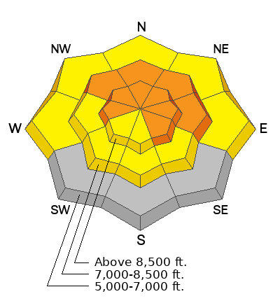
There is CONSIDERABLE avalanche danger on drifted slopes at upper and mid-elevations. People will likely trigger large and destructive avalanches on slopes steeper than 30°. Avalanches failing on a persistent weak layer could be triggered remotely (from a distance) or from the flats below steep slopes. Warm temperatures today will elevate the potential for wet avalanches in sunny and low-elevation terrain.
  • Backcountry parties must incorporate careful snowpack evaluation, cautious route-finding, and conservative decision-making.
  • People should continue to avoid travel on or beneath steep drifted slopes.
Low
Moderate
Considerable
High
Extreme
Learn how to read the forecast here
Weather and Snow
The mountain snowpack is gradually adjusting to the weight of last weekend's productive storm, but large and destructive avalanches remain possible. The shock of very warm temperatures and the sun's heat could cause natural slab avalanche activity on slopes with poor snow structure. Dangerous avalanche conditions exist on drifted slopes above 8500 feet in elevation facing west, northwest, north, northeast, east, and southeast, and on mid-elevation slopes between 7000 feet and 8500 feet facing northwest through east. In these areas, people are likely to trigger dangerous slab avalanches, 2 to 3 feet thick, failing on sugary faceted snow near the ground. Warm temperatures and sun will elevate the danger of wet avalanches on sunny slopes and at lower elevations, below about 7000 feet in elevation. Wet avalanches may threaten fishermen on the Logan River near Temple Fork and in the Dugway area.
We've been staying out of avalanche terrain all week, off of and well out from under steep slopes. The snow is supportable enough to float a sled in most places, but it's still pretty shallow, with plenty of shallowly buried land mines. Southerly low-elevation slopes are bare of snow or still have only minimal snow cover. We urge people to stay off of and out from under steep drifted slopes, as dangerous avalanches can be triggered remotely (from a distance) or from below.

-The 8400' Tony Grove Snotel reports several inches of new snow, with 1.5 inches SWE (snow water equivalent) in the last 48 hours. It's 33° F, with 58 inches of total snow.
-Winds on Logan Peak ( 9700') are currently blowing from the south 20 to 25 mph, with gusts around 40 mph, and it's 27° F.
-It's 31° F at 8800 feet at our Card Canyon station, with 41 inches of total snow.
-On Paris Peak at 9500 feet in Bloomington Canyon, it is 25° F, and the winds blow 15 to 20 mph with gusts near 30 mph from the south-southwest.

Today will be mostly sunny in the mountains, with high temperatures at 8500' near 37° F and winds blowing around 10 mph from the southwest. Snowfall will start up again late tonight, with 1 to 3 inches possible by morning. Low temperatures around 21° F and 11 to 13 mph winds from the south-southwest are expected. Snowfall could be heavy at times tomorrow, with 7 to 11 inches of accumulation possible. Temperatures will remain steady around 22° F, and winds from the west will blow 15 to 20 mph with gusts in the mid 30s.
The weather pattern will remain active through the weekend and into early next week, but we may see a few day's with more benign conditions in the middle of the week.

For more information, visit the UAC weather page here: Weather - Utah Avalanche Center
For Logan-specific weather, go here: Logan Mountain Weather - Utah Avalanche Center
Recent Avalanches
We are very sad to report that there were two confirmed fatalities due to two separate avalanches that happened in the Salt Lake area mountains over the last days of 2024... Main Porter Fork and Davenport Hill
- Large natural avalanches from last weekend were observed this across the Logan Zone.
- On Christmas Eve, two local riders (brothers) had a close call with a large avalanche in Steep Hollow. The accident report is HERE.
- Last Saturday, we remotely triggered an avalanche of drifted storm snow from a lower-angled adjacent slope. Video HERE
You can read all recent local observations HERE.
Ad
Avalanche Problem #1
Persistent Weak Layer
Type
Location
Likelihood
Size
Description
Very weak faceted snow exists near the ground on almost all northerly-facing slopes at upper and mid-elevations. Other persistent weak layers have also been observed higher in the snowpack. Large and dangerous avalanches failing on a persistent weak layer are likely in drifted terrain, and they are possible even in sheltered areas. There were some impressive natural avalanches with last weekend's productive storm, but many of the most suspect slopes in the area have not yet avalanched and may be hanging in a delicate balance, just waiting for a trigger. The list of popular slopes that have yet to avalanche includes the Rodeo and Fairgrounds Bowls on the east side of Logan Peak, 3-Terraces, and the north face of Providence Peak, the east face of Mt Magog, White Pine Knob, Cornice Ridge, Christmas Tree Bowl, Double Top, as well as Wilderness Peak, St. Charles, Slide Canyon, and many more.....
  • Recent avalanches, shooting cracks, and collapsing (whumpfs) are signs of unstable snow, but these obvious signs of instability will not always be present when a large avalanche occurs.
  • Avalanches could be triggered remotely (from a distance) or worse, from below steep slopes in the flats.
Avalanche Problem #2
Wind Drifted Snow
Type
Location
Likelihood
Size
Description
Drifting this week created new slabs of wind-drifted snow in exposed terrain. Recently formed wind slabs likely overloaded slopes with poor snow structure.
  • Avalanches of wind-drifted snow are most likely on the lee side of major ridges.
  • Drifting formed new wind slabs in exposed terrain and in and around terrain features like cliff bands, sub-ridges, gullies, and scoops.
  • Soft, freshly formed wind slabs may be quite sensitive, and some may be remotely triggered. Stiff wind slabs may allow you to get out onto them before releasing, like a giant mouse trap.
Avalanche Problem #3
Wet Snow
Type
Location
Likelihood
Size
Description
Warm temperatures and sun will elevate the danger of loose wet avalanches in sunny terrain and at low elevations.
  • Recent avalanches, roller balls, and pinwheels are signs that wet avalanches are possible
  • Avoid being under steep slopes with saturated snow during the heat of the day
Additional Information
Last Saturday, we remotely triggered a large Avalanche above the Tony Grove Campground. The video is HERE
The crown of a remotely triggered avalanche near Tony Grove Lake.
General Announcements
-National Forest Winter Recreation Travel Maps show where it's open to ride: UWCNF Logan, Ogden LRD Tony Grove, Franklin Basin CTNF Montpelier
-Sign up for forecast region-specific text message alerts. You will receive messages about changing avalanche conditions, watches, and warnings...HERE.
-For all questions on forecasts, education, Know Before You Go, events, online purchases, or fundraising, call 801-365-5522.
-To report an avalanche or submit an observation from the backcountry, go HERE.
-Remember, even though the gate is still open, the Tony Grove Road is not maintained for winter driving.

This forecast is from the U.S.D.A. Forest Service, which is solely responsible for its content. This forecast describes general avalanche conditions, and local variations always occur.