Forecast for the Logan Area Mountains

Toby Weed
Issued by Toby Weed on
Friday morning, January 22, 2021
Elevated avalanche conditions exist and the danger is MODERATE on drifted upper and mid elevation slopes. People could trigger dangerous slab avalanches of wind drifted snow failing on a sugary persistent weak layer near the ground.
Heavy snow from a winter storm tonight will cause increasing avalanche danger, natural avalanches are possible, and we expect dangerous avalanche conditions will develop on many slopes. Tomorrow the avalanche danger may rise to HIGH on steep slopes with significant accumulations of heavy new snow.
  • Evaluate snow and terrain carefully.
Low
Moderate
Considerable
High
Extreme
Learn how to read the forecast here
Avalanche Watch
  • IN EFFECT FROM 6 AM MST THIS MORNING TO 6 AM MST SATURDAY
  • FOR THE MOUNTAINS OF NORTHERN UTAH INCLUDING THE WASATCH RANGE...BEAR RIVER RANGE...UINTA MOUNTAINS.
  • HEAVY SNOWFALL TONIGHT AND TOMORROW WILL OVERLOAD A VERY WEAK SNOWPACK AND CREATE VERY DANGEROUS AVALANCHE CONDITIONS.
Special Announcements
Do you have the essential avalanche rescue gear (transceiver, probe, and shovel) and do you know how to use them? Watch this video to see how the three pieces of equipment work together. HERE
Use the beacon training park at the Franklin Basin Trailhead to practice companion rescue skills.
Weather and Snow
It's 27°F this morning at the Tony Grove Lake Snotel at 8400'. There is a couple inches of new snow from yesterday, and with 35" of total snow, the station reports only 62% of average SWE. It's 20°F on Logan Peak, and the 9700' CSI weather station reports south-southwest wind, averaging 23 mph and gusting in the 30s.
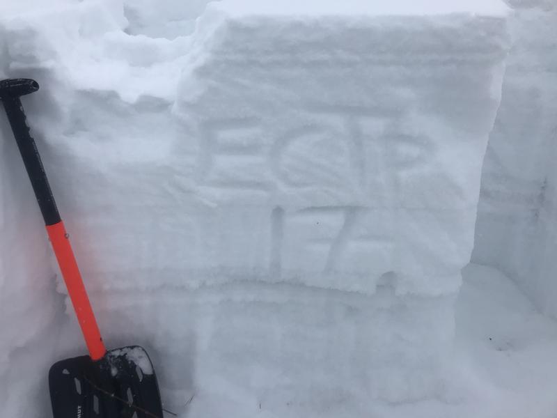
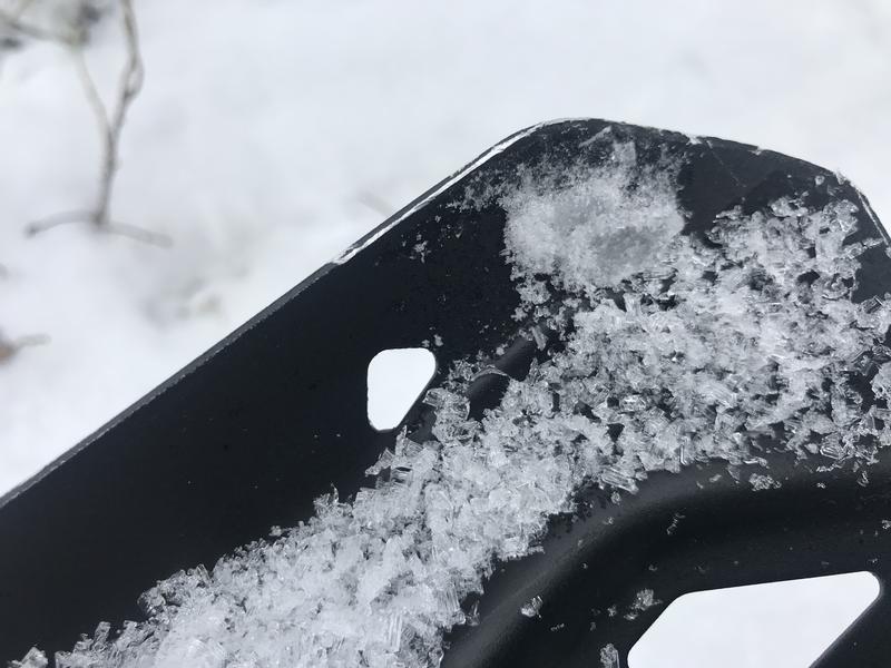
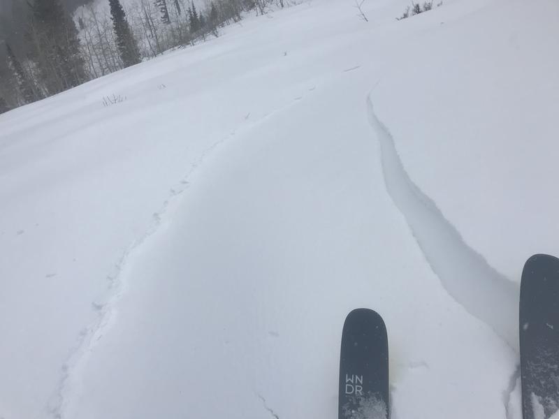
We really need snow, and it looks like we'll get some tonight. The existing snowpack is generally quite shallow in the Logan Zone, and we have a serious problem with widespread very weak sugary snow and a dangerous persistent weak layer near the ground on most slopes. You sink all the way to the ground if you hop off your sled when you're off the beaten track, and breaking trail on skis is very difficult in untracked terrain because you sink way too deeply into loose sugary snow.

We'll see cloudy skies today, and 8500' high temperatures are expected to be around 29°F. South-southwest winds will steadily blow along the ridges, and there is an increasing chance for snow, although not much is expected to accumulate until tonight. A foot of snow or so of accumulation is possible in the Bear River Range tonight and tomorrow, with moderate winds veering from southwest to northwest during the storm. Expect backcountry avalanche danger to rise dramatically across the region on steep slopes where significant snow accumulates, because very weak preexisting snow is widespread and it plagues snow covered slopes at all elevations facing every direction. More snow is likely early next week in a much more progressive weather pattern.
Recent Avalanches
No avalanches have been reported in the Logan Zone since the first week of 2021, when conditions were quite active.
  • A local rider was completely buried in Steep Hollow on 1-8-2021. Thankfully, he was rescued in time by his riding partners. Our accident report shows the details.. HERE
  • In early January there were several large remotely triggered avalanches in the Logan Zone, all triggered by sledders or snow bikers, and luckily from a distance. See the avalanche list HERE.
Ad
Avalanche Problem #1
Persistent Weak Layer
Type
Location
Likelihood
Size
Description
Very weak sugary or faceted snow near the ground is widespread across the region, and people could trigger avalanches where a slab of more cohesive snow has formed on top of the weak snow.
  • Avalanches failing on a buried persistent weak layer might be triggered remotely, from a distance, or worse from below!
  • Cracking and collapsing of the snow are a red flag, indicating unstable snow conditions.
Still finding propegation in snowpit tests yesterday on an east-northeast facing slope at 8400' in the backcountry on the backside of Beaver Mountain.

The sugary, faceted crystals just fall out of the pit wall in some places. People could trigger dangerous avalanches where a cohesive slab has formed on top of a widespread buried persistent weak layer. These large faceted grains are more like the size and texture of rock salt than sugar. This is classic depth hoar, and it's likely to haunt us later in the season when slopes are overloaded by inevitable storms.
Avalanche Problem #2
Wind Drifted Snow
Type
Location
Likelihood
Size
Description
Strong east winds earlier in the week found some snow to drift around. It blew across some slopes and "cross-loaded" them with stiff drifts forming vertically and lower on the slope than usual, and the easterly winds may have built up dangerous hard slabs in unexpected areas. People could trigger avalanches of wind drifted snow, up to 3-foot-thick hard slab avalanches on steep slopes, where drifts formed previously or more recently on slopes with sugary buried persistent weak layers.
  • Watch for and avoid drifted snow at upper and mid elevations near ridge tops and in and around terrain features like gullies, scoops, cliff bands, and sub ridges.
  • Harder wind slabs may allow people to get out on them before releasing.
We cracked out this shallow but hard wind slab near the saddle on Beaver Mountain Backside yesterday, leading me to beleive there are more drifts out there that could be triggered.
Avalanche Problem #3
New Snow
Type
Location
Likelihood
Size
Description
Heavy snowfall is expected in the mountains tonight, causing the avalanche danger to increase significantly! Natural avalanches of new snow are possible late tonight and early tomorrow, especially during periods of particularly heavy snowfall. The load of the new snow may be enough in some areas to overload buried persistent weak layers that are widespread across the zone, and large natural avalanches could result.
Additional Information
Mark and I went up to Tony Grove to look at the snow on 1-5-2021. Our tests showed unstable snow conditions. Watch it HERE.

This video shows what I found in Upper Providence Canyon last week... HERE
This video is from the 1-8-2021 avalanche in Steep Hollow that completely buried a local snow bike rider.
General Announcements
Thanks to the generous support of our local resorts, Ski Utah, and Backcountry, discount lift tickets are now available. Support the UAC while you ski at the resorts this season. Tickets are available here.
Visit this website with information about Responsible Winter Recreation by the Utah Office of Outdoor Recreation.
EMAIL ADVISORY. If you would like to get the daily advisory by email you subscribe HERE.
Remember your information can save lives. If you see anything we should know about, please help us out by submitting snow and avalanche observations....HERE. You can also call us at 801-524-5304, email by clicking HERE, or include #utavy in your tweet or Instagram.
I will update this forecast by around 7:30 tomorrow morning.
This forecast is from the USDA Forest Service, which is solely responsible for its content. The forecast describes general avalanche conditions and local variations always occur.