Check out our Holiday Auction

Forecast for the Logan Area Mountains

Trent Meisenheimer
Issued by Trent Meisenheimer on
Wednesday morning, January 18, 2023
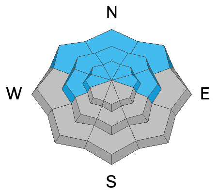
Today the avalanche danger is MODERATE on all steep slopes at the mid and upper elevations. Here it is possible to trigger an avalanche 1-2' deep that fails within the new snow. Also, keep an eye out for loose dry avalanches (sluffs) as they can run long distances and could pack a punch in steep, sustained terrain.

Evaluate snow and terrain carefully, as human-triggered avalanches are possible. Keep an eye on your friends, travel one at a time in avalanche terrain, and have a plan if an avalanche were to happen.
Low
Moderate
Considerable
High
Extreme
Learn how to read the forecast here
Weather and Snow
Under cloudy skies, the last few snowflakes are being squeezed from the atmosphere as our storm moves east. Mountain temperatures have been on a cooling trend, with current temperatures ranging from 10-17°F with a wind chill on Logan Peak at -11°F Brr. Winds have veered to the northwest and are blowing 10-20 mph across the upper elevation ridgelines. Lose some elevation, and there is hardly a puff of wind. In the past 48 hours, we've received roughly 4-8" of new snow (0.2-0.4" of water).
For today, we expect mostly to partly cloudy skies with perhaps a little sunshine in some areas and temperatures rising into the mid-20s °F. Winds will remain from the northwest and blow 10-20 mph across the upper-elevation terrain. Excellent riding and turning conditions can be found on all aspects and elevations.
As one storm exits the arena and slides east into the Great Plains, we will see a slight break in the action today and Thursday before the next storm steps up to the plate. Our next storm is currently off the Oregon Coast and will dig deep as it moves inland, becoming a cut-off low-pressure system that will not favor the Logan area. It looks to be a central and southern Utah special, and unfortunately, we could see pesky northeast winds as it spins over the Four Corners. No worries, we have yet another storm lined up for Sunday into Monday that should have some more cowbell. What a winter we are having!
Recent Avalanches
No new avalanche activity was reported yesterday. Find a list of all observations & avalanches HERE.
Ad
Avalanche Problem #1
New Snow
Type
Location
Likelihood
Size
Description
Small soft slabs and dry loose avalanches within the new snow are possible for people to trigger, especially on steep slopes. If you're getting after steep terrain (slopes greater than 30°), keep an eye on your friends and ride slopes one at a time in case anything were to happen. As always, avoid terrain traps where even small avalanches can pile up deeply.
Be on the lookout for any fresh drift of wind-blown snow and avoid those areas. Here avalanches 1-2 feet deep that fail within the new snow could be large enough to bury a person.
Avalanche Problem #2
Persistent Weak Layer
Type
Location
Likelihood
Size
Description
In many areas in the Logan Zone, the snowpack is becoming so deep (6-10 feet deep) that our old November weak layer of faceted snow is becoming dormant and humans are unlikely to trigger an avalanche to this layer. However, the Logan zone is massive, and we've seen areas where the snowpack is shallower and generally less than 5 feet deep, and these are the areas that I would avoid. For example, the Wellsville and Logan Peak Area are more suspect because they generally hold a shallower snowpack.
General Announcements
  • Remember, when you leave the ski area boundary, Beaver Mt or Cherry Peak, you are entering the backcountry, and you could trigger dangerous avalanches.
  • Please submit your observations from the backcountry HERE.
  • For a list of avalanche classes from the Utah Avalanche Center go HERE
  • For information on where you can ride your sled or snowbike, check out this map of the winter travel plan for the Logan and Ogden Ranger Districts HERE, and a close up of the Tony Grove and Franklin Basin Areas HERE.
This forecast is from the U.S.D.A. Forest Service, which is solely responsible for its content. This forecast describes general avalanche conditions and local variations always occur.