Forecast for the Logan Area Mountains

Toby Weed
Issued by Toby Weed on
Saturday morning, January 16, 2021
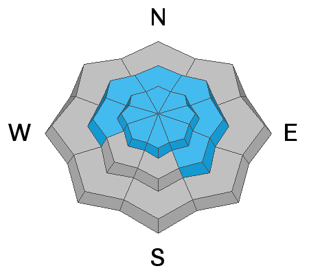
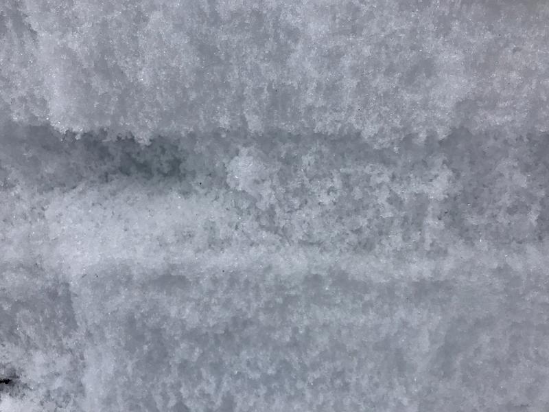
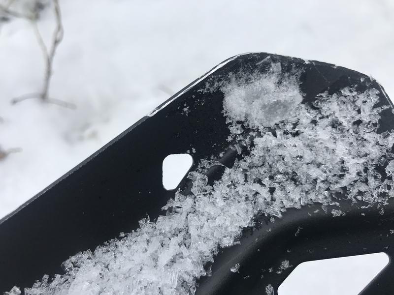
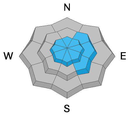
Elevated avalanche conditions exist and the danger is MODERATE on mid and upper elevation slopes. People could trigger dangerous avalanches failing on a sugary persistent weak layer near the ground. Strong winds in the past couple days created hard drifts or wind slabs, and avalanches are most likely on drifted slopes at upper elevations. Avalanches still might be triggered remotely, from a distance, or from below.

You'll find safer and better conditions in lower angled, sheltered terrain. The avalanche danger is LOW in lower elevation terrain because the snow is too shallow or slopes are bare.
  • Evaluate snow and terrain carefully.
  • Continue to stay off and out from under steep drifted slopes.
Low
Moderate
Considerable
High
Extreme
Learn how to read the forecast here
Special Announcements
Check out the UAC's Trailhead Avalanche Awareness Program up at Beaver Creek trailhead, below Beaver Mountain Ski Area. We'll be there to go over current backcountry conditions and avalanche safety best practices. Please stop by.
Weather and Snow
An inch of snow accumulated at upper elevations overnight, which will help refresh riding conditions but is not enough to change avalanche conditions much. There is 35 inches of total snow at the 8400' Tony Grove Lake Snotel, containing only 67% of normal SWE. Very strong and gusty west winds in the past couple days raked upper elevation slopes and built hard drifts on lee slopes and in terrain dictated deposition areas.
Decent riding and skiing options across the Logan Zone are limited to sheltered terrain, and you'll find a variable snow surface in most places. Look for sheltered lower angle slopes, where there may be stashes of fast recrystallized powder to be found. Upper elevation snow is now pretty wind jacked, with satstugi, wind board, breakable, thin wind-crusts, and rime-crusts. The snow pack is generally quite shallow in the Logan Zone and we have a serious problem with widespread very weak sugary snow and a dangerous persistent weak layer near the ground on most slopes.
Snow conditions are somewhat variable across the Logan Zone these days..

We'll see clouds and some sun today, and 8500' temperatures are expected to be around 29°F. West-northwest winds will be blowing moderately along the ridges. It will be fair and sunny this weekend as a high pressure system continues to dominate the weather pattern. Another weak storm will bring a good chance for some light snow Sunday night and Monday, with an inch or two of accumulation possible. A cooler and wetter pattern is anticipated heading through next week, with next possibility for more significant snow arriving late next week and next weekend.
Recent Avalanches
  • On Friday, 1-8-2021, a 31-year-old male snowboarder from Clinton, Utah was killed in an avalanche in Dutch Draw in the backcountry near Park City. The final accident report is HERE.
  • A local rider was caught in a large avalanche that came from above, and he was completely buried under three feet of snow in the Steep Hollow Area Friday, 1-8-2021. Thankfully, he was rescued in time by his riding partners. Watch the video HERE. Our accident report shows the avalanche details.. HERE
  • Last week and weekend there were several large remotely triggered avalanches in the Logan Zone, all triggered by sledders or snow bikers, and luckily from a distance. See the avalanche list HERE.
Ad
Avalanche Problem #1
Persistent Weak Layer
Type
Location
Likelihood
Size
Description
Very weak sugary or faceted snow near the ground is widespread across the region, and people could trigger avalanches where a slab of more cohesive snow has formed on top of the weak snow.
  • Avalanches failing on a buried persistent weak layer might be triggered remotely, from a distance, or worse from below!
  • Cracking and collapsing of the snow are a red flag, indicating unstable snow conditions.
The sugary, faceted crystals in this widespread persistent weak layer just fall out of the pit wall in some places. People could trigger dangerous avalanches where a cohesive slab has formed on top of this buried layer.
These large faceted grains are more like the size and texture of rock salt than sugar. This is classic depth hoar, and it's likely to haunt us later in the season when slopes are overloaded by inevitable storms.
Avalanche Problem #2
Wind Drifted Snow
Type
Location
Likelihood
Size
Description
People could trigger avalanches of wind drifted snow, up to 3-foot-thick hard slab avalanches on steep slopes, where drifts formed on slopes with buried persistent weak layers.
  • Watch for and avoid drifted snow at upper and mid elevations near ridge tops and in and around terrain features like gullies, cliff bands, and sub ridges
  • Harder wind slabs may allow people to get out on them before releasing.
Additional Information
Mark and I went up to Tony Grove to look at the snow on 1-5-2021. Our tests showed unstable snow conditions. Watch it HERE.

This video shows what I found in Upper Providence Canyon last week... HERE
General Announcements
Thanks to the generous support of our local resorts, Ski Utah, and Backcountry, discount lift tickets are now available. Support the UAC while you ski at the resorts this season. Tickets are available here.
Visit this website with information about Responsible Winter Recreation by the Utah Office of Outdoor Recreation.
EMAIL ADVISORY. If you would like to get the daily advisory by email you subscribe HERE.
Remember your information can save lives. If you see anything we should know about, please help us out by submitting snow and avalanche observations....HERE. You can also call us at 801-524-5304, email by clicking HERE, or include #utavy in your tweet or Instagram.
I will update this forecast by around 7:30 Monday morning.
This forecast is from the USDA Forest Service, which is solely responsible for its content. The forecast describes general avalanche conditions and local variations always occur.