Forecast for the Abajos Area Mountains

Eric Trenbeath
Issued by Eric Trenbeath on
Sunday morning, April 5, 2020
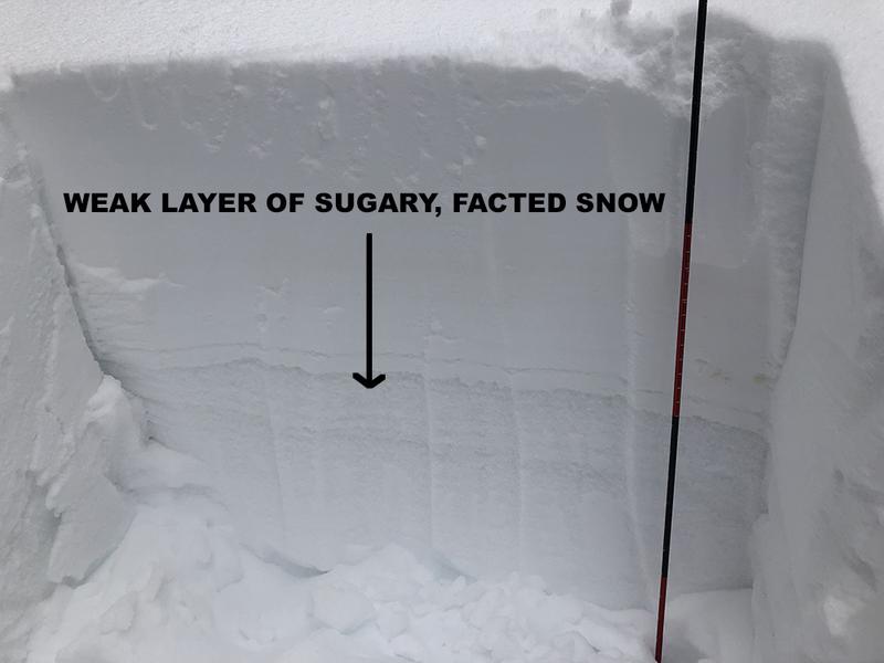
Most terrain has generally LOW danger. An isolated or MODERATE danger exists for triggering an avalanche on a buried persistent weak layer of loose, sugary, faceted snow. Areas of very steep, rocky, radical terrain where the snowpack is shallower and weaker are the most suspect. With a strong sun this time of year, always be alert to an increasing danger for loose, wet avalanches on sun-exposed slopes. Signs of instability include rollerballs pinwheels and point release sluffs. Get off of and out from under steep slopes that become wet and sloppy.
Low
Moderate
Considerable
High
Extreme
Learn how to read the forecast here
Special Announcements
Spring Awareness Campaign - Help us save lives through avalanche forecasts and education. Consider making a donation before April 8th.
We are sad to share the news of two recent avalanche fatalities:
On Wednesday, Trace Carrillo died in an avalanche on Taylor Mountain near Teton Pass. Trace was formerly an intern with the UAC and more recently a wilderness ranger with the Forest Service. Article here. Preliminary report here.
On Friday, Rob Kincaid died in an avalanche just north of Palisades Reservoir near the ID/WY stateline. Rob was well known by many snowmobilers as an athlete for Arctic Cat and veteran of many snowmobile competitions. Article here. Preliminary report here.
More details should be available soon about these tragic events but initial reports are that both men were wearing avalanche transceivers that were not turned on.

January 5, 2019 - Read this collection of 6 stories and a podcast about that day with a low avalanche danger, 8 skier-triggered avalanches, four catch and carries, a partial and critical burial, and a trip to the emergency room.
Weather and Snow
Weather: Stop me if you've heard this before - overnight, southwesterly winds cranked in the 20-30 mph range with gusts into the 40's. They've backed off a bit this morning into the 15-20 mph range. today look for mostly sunny skies with breezy and warm conditions. High temps will again reach the mid 40's. Mon-Wed looks dry and sunny with the next closed low off the Pacific coast moving into the area sometime Thursday.
Snowpack: In our travels yesterday, we found a mixed bag of spring conditions. Some soft, dry snow can still be found on sheltered, shady aspects, and supportable corn-like snow is developing on S-W facing slopes. Deeper in the snowpack, a layer of weak, sugary, faceted snow exists on northerly aspects. In isolated areas, it may be possible to trigger an avalanche down to this buried weak layer. Areas of very steep, rocky, radical terrain where the snowpack is shallower and weaker are the most suspect.
Kevin Dressel photo.
Snow totals at Buckboard Flat (8924')
Snow totals at Camp Jackson (8858')
Additional Information
Information on outdoor recreation - The State of Utah created this webpage with information about recreating on both state and federal public lands during the current health crisis.

New to the backcountry (including riding at closed resorts) - Watch the award-winning, 15 minute Know Before You Go video, or take the 5-part, free online-learning series.
General Announcements
This forecast is from the U.S. Forest Service, which is solely responsible for its content. This forecast describes general avalanche conditions and local variations always occur.