Forecast for the Abajos Area Mountains

Eric Trenbeath
Issued by Eric Trenbeath on
Sunday morning, March 31, 2019
The avalanche danger is generally LOW and mostly stable snow conditions exist. Maintain avalanche awareness, continue to practice safe travel techniques.
Low
Moderate
Considerable
High
Extreme
Learn how to read the forecast here
Special Announcements
Utah has a rich history of avalanches. From the earlier mining days of Alta to the start of avalanche research and snow science in the US in Little Cottonwood Canyon in 1939. Snowpack and weather data has been collected from the Alta Guard Station every year since making it the longest snow plot history in the US. These roots made the UAC an early leader in avalanche education and forecasting.
Weather and Snow
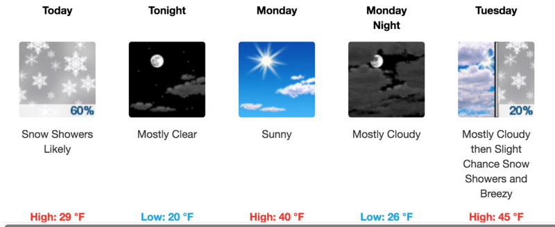
Skies are mostly cloudy, NE winds are mostly light, and temps are in the mid 20's. Look for a chance of snow showers today with only trace amonts of accumulation. NE winds will be light, and high temps will be around freezing. Skies should clear later today and tomorrow will be mostly sunny. An unsettled weather pattern is on tap for the week with the next chance for snow on Tue-Wed.

Snotel totals at Buckboard Flat (8924')
Snotel totals at Camp Jackson (8858')
Wind, temperature, and humidity on Abajo Peak (11,000')
National Weather Service point forecast.
Avalanche Problem #1
Normal Caution
Type
Location
Likelihood
Size
Description
Backcountry travel in snow covered mountains should always be done with an awareness for avalanche potential, and LOW danger doesn't mean NO danger. Continue to practice safe travel techniques by only putting one person on a slope at a time. Be alert to changing weather conditions and keep the following avalanche problems in mind:
Wet Snow: On warm, sunny days you need to be alert to a rising danger for wet snow avalanches. Signs of instability include roller balls, pinwheels, and loose, wet sluffs. Follow the sun and get off of steep slopes if they become wet and sloppy.
Wind Drifted Snow: Always be on the lookout for areas of wind drifted snow on the leeward sides of ridge crests and terrain features. They are often recognizable as smooth, rounded pillows, or they may feel and sound hollow like a drum. Old, hard wind slabs will be harder to trigger, but they will also have higher consequences. Even a small wind slab release could be devastating if it swept you over a cliff. Choose terrain wisely and with regard for consequences.
New Snow: 6" or more of new snow can cause a rise in the avalanche danger. Sluffiung and soft slabs are possible.
General Announcements
Your information can save lives. If you see anything we should know about, please help us out by submitting snow and avalanche observations HERE. You can also call me at 801-647-8896, or send me an email: eric@utahavalanchecenter.org.
Support the UAC through your daily shopping. When you shop at Smith's, or online at REI, Backcountry.com, Patagonia, NRS, Amazon, eBay by clicking on these links, they donate a portion of your purchase to the UAC. If you sell on eBay, you can have your See our Affiliate Page for more details on how you can support the UAC when you shop
This forecast is from the U.S.D.A. Forest Service, which is solely responsible for its content. This forecast describes general avalanche conditions and local variations always occur.