Forecast for the Abajos Area Mountains

Eric Trenbeath
Issued by Eric Trenbeath on
Saturday morning, March 28, 2020
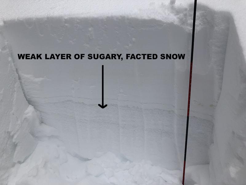
New snow and wind have conspired to form fresh drifts at upper elevations and the avalanche danger is MODERATE on steep, wind drifted slopes. Look for fresh wind drifts on the leeward sides of ridge crests and terrain features. Wind drifts are recognizable by their smooth rounded appearance, and cracking is a sign of instability. On slopes facing the north half of the compass, an isolated possibility exists for an avalanche to fail on a buried persistent weak layer of loose, sugary, faceted snow. Most other terrain has generally LOW danger.
Low
Moderate
Considerable
High
Extreme
Learn how to read the forecast here
Special Announcements
If you rely on the UAC forecasts each day you get out, consider making a donation during our Spring Awareness Campaign to help us continue providing the avalanche forecasts and education you rely on.
The UAC encourages everyone to follow direction from federal, state, city and county officicals. The following is from Joe Dougherty, spokesman for the Utah Division of Emergency Management:
Though outdoor recreation is still permitted under the governor’s Stay Safe/Stay Home directive, we recommend that people maintain a distance of at least 6 feet.
Be extra cautious to avoid injuries outdoors. We are working with our hospital systems to conserve as much personal protective equipment as possible in case of hospitalizations.
Most outdoor injuries can be prevented. Know the conditions and know your limits so you don’t end up in a hospital.
Weather and Snow
Weather: The mountains picked up between 4"-6" of new snow and winter has yet to release its icy grip. Southwest winds during the storm averaged 15-20 mph along ridge tops with gusts near 30 before switching to the NW by early evening. A second wave of showers occurred early this morning and clouds are still hanging over the mountains. Look for clearing skies today with light to moderate NW winds and unseasonably cool temps with high temps reaching into the upper 20's. The next weak wave will move into the region late Sunday afternoon and evening.
Snowpack: The new snow will provide a nice refresh, especially on sheltered slopes where soft snow existed prior to the storm Sun exposed slopes are crusty underneath. Fresh wind drifts will be found on leeward slopes, primarily at upper elevations. Deeper in the snowpack, a layer of weak, sugary, faceted snow exists. In isolated areas, a triggered wind drift could step down to this buried weak layer causing a deeper and more dangerous avalanche.
Kevin Dressel photo.
Snow totals at Buckboard Flat (8924')
Snow totals at Camp Jackson (8858')
Additional Information
New to the backcountry (including riding at closed resorts) - Watch the award-winning, 15 minute Know Before You Go video, or take the 5-part, free online-learning series.
General Announcements
This forecast is from the U.S. Forest Service, which is solely responsible for its content. This forecast describes general avalanche conditions and local variations always occur.