UDOT PLANNED AVALANCHE CLOSURES!!

Forecast for the Abajos Area Mountains

Eric Trenbeath
Issued by Eric Trenbeath on
Sunday morning, March 24, 2019
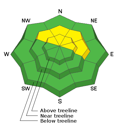
The avalanche danger is MODERATE and human triggered avalanches involving wind drifted snow are possible. Steep, upper elevation, wind drifted slopes that face NW-N-E are where you are most likely to encounter a problem. There also remains an isolated, or MODERATE danger for triggering a deep avalanche, failing on a buried persistent weak layer. Though the likelihood of triggering this type of avalanche has lessened, the consequences have not, and this type of avalanche is un-survivable. The problem is most acute on steep slopes facing NW-N-E right around treeline and above. Most south facing, and low elevation terrain offers LOW danger.
Low
Moderate
Considerable
High
Extreme
Learn how to read the forecast here
Special Announcements
A big shout out to the sledders in San Juan County who completed a Motorized Backcountry 101 Course this weekend! And a huge thanks to Al and Eston from Backcountry Institute for putting on the course!
Weather and Snow
SW winds are averaging 15-20 mph along ridge tops, and 10,000' temps are in the mid 20's. Today look for partly sunny skies with a few scattered snow showers, continued SW winds in the 15-20 mph range with gusts to 30, and daytime high temps in the mid 30's. Tomorrow will see sunny skies and warmer temperatures.
12" -14" of snow at 1.5" of water weight fell across the range Thursday night into Friday, and conditions have been about as good as they get in late March. Cloud cover kept the snow good for most of the day yesterday, but lower elevations and sun exposed slopes succumbed to the heat by afternoon.The snowpack in the Abajos is very deep. Snow depths near 10,000 feet range from 7 feet to 11 feet.

Snotel totals at Buckboard Flat (8924')
Snotel totals at Camp Jackson (8858')
Wind, temperature, and humidity on Abajo Peak (11,000')
National Weather Service point forecast.
Additional Information
Carry appropriate rescue gear: beacon, probe, shovel, and choose where you ride based on the avalanche forecast for the day!
General Announcements
Your information can save lives. If you see anything we should know about, please help us out by submitting snow and avalanche observations HERE. You can also call me at 801-647-8896, or send me an email: eric@utahavalanchecenter.org.
Support the UAC through your daily shopping. When you shop at Smith's, or online at REI, Backcountry.com, Patagonia, NRS, Amazon, eBay by clicking on these links, they donate a portion of your purchase to the UAC. If you sell on eBay, you can have your See our Affiliate Page for more details on how you can support the UAC when you shop
This forecast is from the U.S.D.A. Forest Service, which is solely responsible for its content. This forecast describes general avalanche conditions and local variations always occur.