Forecast for the Abajos Area Mountains

Issued by Chris Benson on
Tuesday morning, March 23, 2021
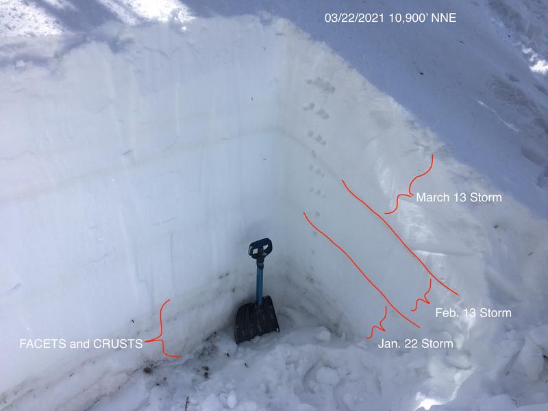
The avalanche danger is MODERATE on steep upper elevation, wind drifted slopes that face NW-N-NE where it is still possible to trigger an avalanche on a buried, persistent weak layer of sugary, faceted snow. Thinner snowpack areas and slopes with steep, rocky, more radical terrain are the most likely places to trigger an avalanche. Most other terrain has generally LOW danger.
Low
Moderate
Considerable
High
Extreme
Learn how to read the forecast here
Special Announcements
The 2021 Spring Awareness Campaign is underway. Help us save lives through avalanche forecasts and education. Consider making a donation to show your support HERE.
Over the last couple of days, two different fatal avalanche accidents have occurred in CA and CO. Our deepest condolences to the friends and families of these victims.
Weather and Snow
Look for mostly cloudy skies with 1-3" of snow possible throughout the day as a low-pressure trough digs into the 4 Corners Region. Expect light to moderate NW winds 5-15 mph. High temps at 10,000' will be near 35F. A transient ridge will push this system east by tomorrow night. The next system enters our area mid-day on Thursday and will bring more unsettled weather for the high country.
Snow totals at Buckboard Flat (8924')
Snow totals at Camp Jackson (8858')
Snowpack Discussion
Overall conditions are variable and crusty. Yesterday, we found good skiing on sheltered northerly aspects. Snowpack tests revealed that we still have a poor snowpack structure, but suspect weak layers are far-enough down in the snowpack that it will be difficult to affect them. Last week's storm appears to be bonding well to the old snow. Time and warm temperatures have helped stabilize the snowpack but it is still possible to trigger a deep and dangerous avalanche on a buried persistent weak layer of sugary, faceted snow. This weak layer exists on slopes that face NW-N-E, and thin snowpack areas consisting of steep, rocky terrain are the most likely trigger points. Here is a snapshot of the snowpack near Cooley Pass.
Additional Information
Information on outdoor recreation - The State of Utah created this webpage with information about recreating on both state and federal public lands during the current health crisis.

New to the backcountry (including riding at closed resorts) - Watch the award-winning, 15 minute Know Before You Go video, or take the 5-part, free online-learning series.
General Announcements
This forecast is from the U.S. Forest Service, which is solely responsible for its content. This forecast describes general avalanche conditions and local variations always occur.