Forecast for the Abajos Area Mountains

Eric Trenbeath
Issued by Eric Trenbeath on
Saturday morning, March 21, 2020
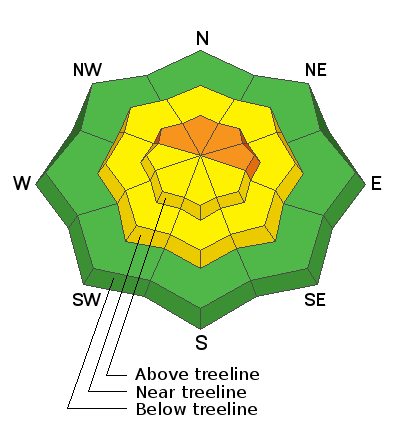
The avalanche danger remains CONSIDERABLE on steep, upper elevation slopes that face NW-N-E where human triggered avalanches involving new and wind drifted snow are likely. On isolated slopes in these same areas, human triggered avalanches failing on a buried persistent weak layer of loose, sugary, faceted snow are possible. Most mid-elevation and south-facing terrain have a MODERATE avalanche danger. Low elevations have generally LOW danger. Avoid steep, wind drifted slopes today, and look for signs of instability such as cracking in the snow surface.
Low
Moderate
Considerable
High
Extreme
Learn how to read the forecast here
Special Announcements
We know there is a lot of uncertainty regarding the Coronavirus, but the Utah Avalanche Center is planning to continue issuing regular avalanche forecasts into April.
Weather and Snow
Light snow continued to fall throughout the day yesterday adding another couple of inches, and bringing 2-day totals up to between 12"-16". SE winds were pretty well behaved yesterday averaging just 15 mph but with regular gusts into the upper 20's. Today look for mostly cloudy skies and scattered snow showers. Southerly winds will be mostly light and high temps will be in the upper 20's. We should see mostly sunny skies tomorrow before the next system moves into the region on Monday. Hello Spring!
Conditions are vastly improved and Kevin Dressel who was up yesterday reported as much. He also got a look at Thursday's reported avalanche. Read his observation here. Moderate winds have blown and drifted snow at upper elevations and, yesterday's snow came in slightly heavier so we have an inversion in there. As such, new and wind drifted snow are your primary avalanche concerns today.
Snow totals at Buckboard Flat (8924')
Snow totals at Camp Jackson (8858')
Recent Avalanches
I received this report of a natural avalanche on Horsehead Mountain that occurred on Thursday. It was reported as 100' wide on a steep, NE aspect around 11,000'. I don't have many details beyond that. I suspect this slide was storm slab avalanche involving the most recent snow, but it's possible that it could have stepped down into looser, weak, faceted snow that has been developing over the past several weeks.
General Announcements
This forecast is from the U.S. Forest Service, which is solely responsible for its content. This forecast describes general avalanche conditions and local variations always occur.