


Forecast for the Abajos Area Mountains

Issued by Eric Trenbeath on
Sunday morning, February 9, 2020
Sunday morning, February 9, 2020
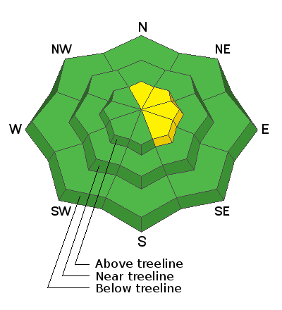
Most terrain has generally LOW danger. An isolated or MODERATE danger exists on steep slopes at upper elevations facing N-E-SE that have deposits of wind drifted snow. Drifts are recognizable by their smooth, rounded appearance and they may sound or feel hollow like a drum. Approach steep slopes with blind convexities or break-overs with caution.
Low
Moderate
Considerable
High
Extreme
Learn how to read the forecast here
 Special Announcements
Are you looking to improve your avalanche skills? We are offering a Backcountry 101: Introduction to Avalanches class on February 15-16 in Moab. Click here to register. A huge thanks to Moab Gear Trader for sponsoring this course. Please visit them for all your winter backcountry needs.
New UAC Podcast: The Art of Storytelling Through Film - A Conversation with Trent Meisenheimer check it out HERE.
 Weather and Snow
It was a beautiful, if not breezy day in the mountains yesterday with high temps in the mid to upper 30's. Today we'll see mostly cloudy skies and a chance for snow as yet another storm clips by to the north. South winds this morning should shift to more northerly and back off into the 10-15 mph range. High temps will be in the mid 20's. Monday looks to be mostly sunny with another chance for snow on Tuesday as a system moves through Arizona. The rest of the week looks dry.
Kevin Dressel and I were out on Friday and found variable conditions with lots of wind affected snow. We still managed to find some good turning in the woods. Check out the week in review video below, it includes both the La Sal and Abajo Mountains.
Snow totals at Buckboard Flat (8924')
Snow totals at Camp Jackson (8858')
 Recent Avalanches
General Announcements
This forecast is from the U.S. Forest Service, which is solely responsible for its content. This forecast describes general avalanche conditions and local variations always occur.