Forecast for the Abajos Area Mountains

Eric Trenbeath
Issued by Eric Trenbeath on
Friday morning, February 5, 2021
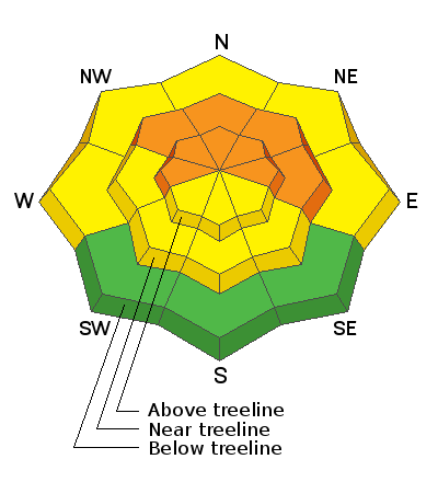
The avalanche danger remains CONSIDERABLE on steep slopes facing NW-N-E at mid and upper elevations and deep and dangerous human triggered avalanches are likely in these areas. The sparse coverage makes conditions deceiving, but in these areas, the underlying snow is very weak and sugary and is providing an unstable base for slabs that have formed on top. Cautious route-finding in these areas is essential. Most other terrain has a MODERATE danger trending towards LOW on more southerly aspects.
Low
Moderate
Considerable
High
Extreme
Learn how to read the forecast here
Special Announcements
In the last six days, there have been 10 avalanche fatalities - 3 skiers in Colorado, 1 skier in Colorado, 3 hikers in Alaska, 1 skier in New Hampshire, 1 skier in California, and 1 skier in Utah on Square Top Mountain near Park City.
Conditions are dangerous in most regions, and ours is no exception. Please stay conservative in your terrain choices.
Weather and Snow
A strong storm system embedded in a northwest flow will bring snow to Northern Utah and Colorado while leaving us high and dry in the south. Today look for partly sunny skies, blustery, westerly winds blowing in the 10-20 mph range with gusts in the 30's. High temps at 10,000' will be in the lower 20's. Conditions remain dry through the weekend. Varying model solutions suggest the next opportunity for a chance of snow will come on late Tues-Wed. Most solutions favor a moderate snow event for northern Utah and north-central Colorado. The GFS model is the outlier that shows snow for our region. Confidence in this solution is currently low.
Snow totals at Buckboard Flat (8924')
Snow totals at Camp Jackson (8858')
Snowpack Discussion
Last week's storm cycle nearly doubled our snowpack and depths range from 2'-4' deep on northerly aspects. Coverage on south-facing terrain remains quite thin with some slopes continuing to show bare ground. The sparse coverage makes conditions deceiving, but dangerous human triggered avalanches remain likely in steep, northerly facing slopes. In these areas, the underlying snow, however, is very weak and sugary and is providing an unstable base for slabs that have formed on top. Kevin Dressel was up on Wednsesday and reported unstable conditons with reactive stability tests. See his report here.
Additional Information
Information on outdoor recreation - The State of Utah created this webpage with information about recreating on both state and federal public lands during the current health crisis.

New to the backcountry (including riding at closed resorts) - Watch the award-winning, 15 minute Know Before You Go video, or take the 5-part, free online-learning series.
General Announcements
This forecast is from the U.S. Forest Service, which is solely responsible for its content. This forecast describes general avalanche conditions and local variations always occur.