Forecast for the Abajos Area Mountains

Brett Kobernik
Issued by Brett Kobernik on
Thursday morning, February 27, 2020
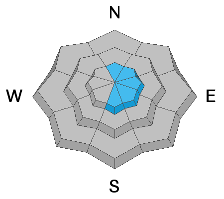
The avalanche danger remains MODERATE in the higher terrain on steep slopes where recent deposits of wind drifted snow exist. Avoid "pillowy" looking drifts especially along the higher ridges. Away from wind affected terrain, the avalanche danger is generally LOW.
Low
Moderate
Considerable
High
Extreme
Learn how to read the forecast here
Special Announcements
The UAC's Avy Awareness Auction is currently underway with tons of great gear, jewelry, artwork and experiences available. Visit the auction page here to help support the UAC's spring avalanche awareness and outreach efforts.
A new version of the UAC IOS application is now available on the Apple App Store. This version fixes many of the issues that occur when running IOS 13.
Weather and Snow
Weather: It was a much nicer day on Wednesday compared to Tuesday. Skies were clear, temperatures were warmer and the wind was a lot slower. We should see another nice day today with slightly warmer temperatures (lower to mid 30s), mostly clear skies and light to moderate speed northwest wind. Friday looks similar with even slightly warmer temperatures yet. The next chance for snow looks like Sunday into Monday with a small storm moving through that might bring a few inches of snow.
Snowpack: Wednesday was my first time in the Abajo Mtns in the winter and I was happy to not find the same type of horrible snowpack that exists right now in the La Sal mountains. In short, the snowpack in the La Sal mountains is almost unsupportable as the snowpack is comprised almost entirely of faceted sugar snow. The snowpack in the Abajo mountains is a bit deeper and is supportable without all of the weak snow deep in the pack. Don't get me wrong, you'll find some weak snow around but overall it's much better than the La Sals. The total depth averages about 4'. There is more than that in many areas. The surface conditions are not very good as the recent wind has taken it's toll. However, there is still nice soft settled snow in sheltered locations that provides great riding.
Snow totals at Buckboard Flat (8924')
Snow totals at Camp Jackson (8858')
Recent Avalanches
Avalanche Problem #1
Wind Drifted Snow
Type
Location
Likelihood
Size
Description
Recently formed drifts are your main avalanche concern right now. If you trigger something, it most likely won't be all that large but you should consider the consequences if you were to get caught and perhaps pushed through trees or over rocks. During my travels on Wednesday, I did experience a localized "whoomp" as I was walking on a recently formed wind drift. Our ace backcountry observer Kevin Dressel was with me and he related that he's experienced similar small collapses this week. This tells us that the fresh drifts are sensitive and definitely could release on steep slopes. Continue to use caution in steep, radical exposed terrain where recent deposits of wind drifted snow are present.
General Announcements
This forecast is from the U.S. Forest Service, which is solely responsible for its content. This forecast describes general avalanche conditions and local variations always occur.