Forecast for the Abajos Area Mountains

Eric Trenbeath
Issued by Eric Trenbeath on
Saturday morning, February 13, 2021
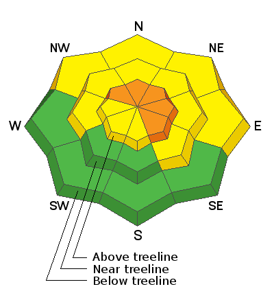
Heads up! Rising avalanche danger through the weekend! The avalanche danger is MODERATE this morning but will likely rise to CONSIDERABLE later today. New and wind drifted snow will add stress to buried persistent weak layers and deep and dangerous, human triggered avalanches will become increasingly more likely on steep slopes facing NW-N-SE. If we see more than about 6" of new snow, storm snow avalanches will be possible on all aspects. Backcountry travelers need to be alert to changing conditions such as accumulating and wind drifted snow. Look for signs of instability such as cracking and collapsing, and continue to avoid steep slopes facing NW-N-SE.
Low
Moderate
Considerable
High
Extreme
Learn how to read the forecast here
Special Announcements
The accident report for the tragic avalanche that killed four skiers in Millcreek Canyon on Saturday, Feb 6, is complete. All were well-known members of the backcountry community and all of us at the UAC are deeply affected. Our deep and sincere condolences go out to the family and friends so affected by this accident.
Weather and Snow
Yesterday's storm produced a few inches of snow for the Abajo mountains. The next, stronger looking system is currently over western Utah with the trough projected to deepen over the region later today. A lot of factors point to a decent shot of snow out of this, but the splitty nature of the trough still gives me some cause for concern. Today, look for snow showers to develop around noon with 3"-5" possible by this evening. SW winds will be on the increase averaging 15-25 mph along ridge tops with gusts as high as 30. Snowfall should continue overnight with up to a foot possible by tomorrow. Snowfall should largely be over by Sunday morning along with an influx of cold air and a shift to northwesterly winds. The next system will move in Monday night into Tuesday.
Snow totals at Buckboard Flat (8924')
Snow totals at Camp Jackson (8858')
Snowpack Discussion
New and wind drifted snow will cause an increase in avalanche danger today and tomorrow. Be alert to changing conditions and watch for signs of instability such as cracking and collapsing. New and wind drifted snow will add additional stress to buried weak layers of loose, sugary, faceted snow increasing the danger of triggering a deep and dangerous avalanche on all northerly aspects and steep slopes in these areas should be avoided. Kevin Dressel was up yesterday and noted poor snowpack structure, even at low elevations. Read his observation here.
Additional Information
Information on outdoor recreation - The State of Utah created this webpage with information about recreating on both state and federal public lands during the current health crisis.

New to the backcountry (including riding at closed resorts) - Watch the award-winning, 15 minute Know Before You Go video, or take the 5-part, free online-learning series.
General Announcements
This forecast is from the U.S. Forest Service, which is solely responsible for its content. This forecast describes general avalanche conditions and local variations always occur.