Forecast for the Abajos Area Mountains

Eric Trenbeath
Issued by Eric Trenbeath on
Wednesday morning, December 30, 2020
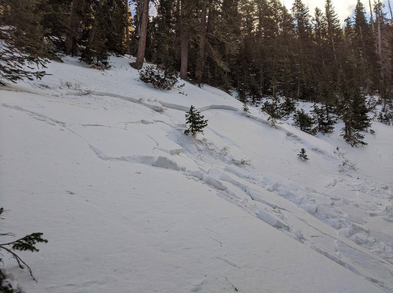
Up to a foot of new snow at upper elevations has added a significant load to our weak, underlying snowpack and the avalanche danger is CONSIDERABLE on steep, northerly facing slopes that had a foot or more of pre-existing snow. In these areas, new and wind drifted snow has piled on top of layers of weak, sugary, faceted snow. This persistent weak layer problem will be with us for the foreseeable future and steep, northerly facing slopes should be avoided. Even a small avalanche triggered under these conditions can have serious and painful consequences. South-facing slopes have a LOW to MODERATE danger for avalanches due to spotty or non-existent prior snow cover.
Low
Moderate
Considerable
High
Extreme
Learn how to read the forecast here
Weather and Snow
Mountain Weather
Skies are clear and temps have crashed. Overnight northerly winds have been mostly light but they started bumping up around 5:00 a.m. It will be a beautiful day in the mountains with sunny skies, fresh snow, and high temps in the mid 20's. We'll see clouds on Thursday as weak disturbance clips by to the north. Dry conditions return through the weekend though we may seem so clouds as several troughs move across the northern region. Long-range models hint at one of these troughs dropping down over our region early next week.
Snowpack Discussion
6"-8" of snow fell in lower North Creek with up to a foot likely at upper elevations. Coverage prior to this storm was quite thin and many sun-exposed slopes were dry. On shady aspects, depths ranged from 6"-18". The existing snow structure is very poor. In exposed areas, stiff slabs overly this weak, sugary snow, and frequent cracking and collapsing of the snowpack is occurring. These are clear red flag signs of instability. The new snow load will add additional stress to the fragile snowpack, and human triggered avalanches are likely on steep, northerly aspects that had pre-existing snow that was deeper than about 12".
Snow totals at Buckboard Flat (8924')
Snow totals at Camp Jackson (8858')
Recent Avalanches
Dustin Randall from ROAM Industry sent in this photo of an avalanche he remotely triggered on a steep, northerly facing slope near 10,000' last week. In spite of the low snow conditions, the existing, underlying snow is very weak, and anywhere that a slab exists on top, is primed and ready for an avalanche. This is exactly the type of setup we are concerned with right now and the additional snow load will make this type of avalanche more likley.
Additional Information
Information on outdoor recreation - The State of Utah created this webpage with information about recreating on both state and federal public lands during the current health crisis.

New to the backcountry (including riding at closed resorts) - Watch the award-winning, 15 minute Know Before You Go video, or take the 5-part, free online-learning series.
General Announcements
This forecast is from the U.S. Forest Service, which is solely responsible for its content. This forecast describes general avalanche conditions and local variations always occur.