Forecast for the Abajos Area Mountains

Eric Trenbeath
Issued by Eric Trenbeath on
Sunday morning, December 29, 2019
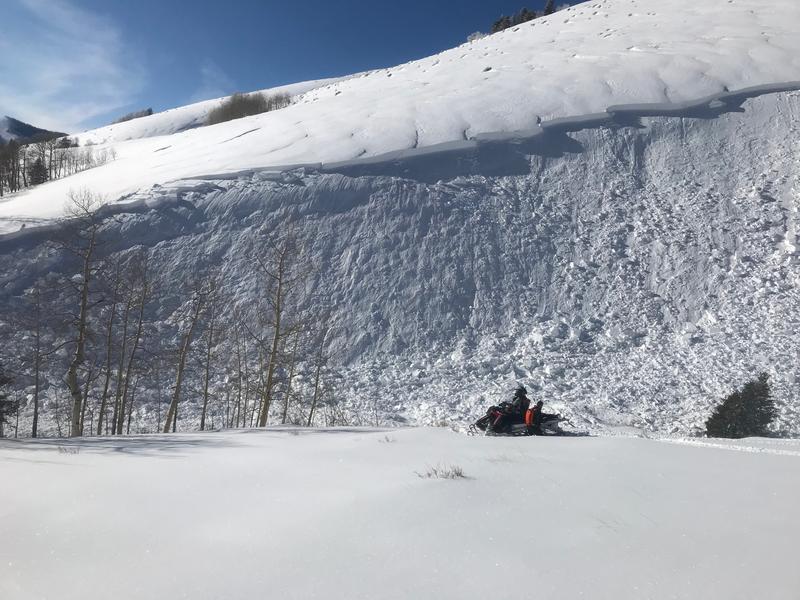
Heavy snowfall and strong winds have created dangerous avalanche conditions. The avalanche danger is CONSIDERABLE and human triggered avalanches are likely. Avoid steep, avalanche-prone slopes today. Backcountry travelers need to possess excellent route finding and snow stability analysis skills. Stick to low angle terrain and meadows, and stay out from under run out zones.
Low
Moderate
Considerable
High
Extreme
Learn how to read the forecast here
Weather and Snow
A few clouds still linger over the mountains, temps are in the single digits, and northerly winds are on the increase averaging 20-25 mph along ridge tops. Skies should remain clear today with high temps creeping up to around 10 degrees. We'll see cold dry air for the next few days before an active pattern kicks in again around the New Year.
After a mostly dry December, storms during Christmas week delivered bringing 2'-3' of snow to the mountains. Backcountry observers are reporting excellent riding and turning conditions but signs of instability such as cracking and collapsing in the snowpack remain present. Remain conservative in your terrain choices and allow the snowpack to adjust to the recent load.
Webcam image courtesy of Kevin Dressel.
Snow totals at Buckboard Flat (8924')
Snow totals at Camp Jackson (8858')
Wind, temperature, and humidity on Abajo Peak (11,000')
Recent Avalanches
A snowmobiler triggered a large avalanche in the Abajos on Thursday. Details are scant at this time but he apparently took a ride and deployed his airbag. This photo just shows a small portion of the slide which extends to the right and up along the ridge crest for several hundred feet. Note the telltale signs if wind drifted snow above the fracture line.
General Announcements
This forecast is from the U.S. Forest Service, which is solely responsible for its content. This forecast describes general avalanche conditions and local variations always occur.