Forecast for the Abajos Area Mountains

Eric Trenbeath
Issued by Eric Trenbeath on
Friday morning, December 27, 2019
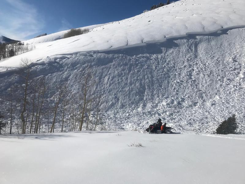
Heavy snowfall and strong southerly winds have created dangerous avalanche conditions. The avalanche danger is HIGH on steep, upper elevation wind drifted slopes that face W-N-E. The danger is CONSIDERABLE on steep, north-facing slopes at mid and lower elevations and human triggered avalanches are likely in these areas. Avoid steep slopes with wind drifted snow and stay out from under runout zones. Only backcountry travelers with excellent route finding and snow stability assessment skills should be out today.
Low
Moderate
Considerable
High
Extreme
Learn how to read the forecast here
Weather and Snow
The snow machine is back on and 4" of new snow has fallen since 3:00 a.m. SE winds picked up again yesterday evening and they have been blowing steady in the 20-25 mph range with gusts in the 30's ever since. Look for continued snow today with 4"-8" possible. Winds will shift to the SW by afternoon, averaging 20 mph along ridge tops. Daytime high temps will be in the low 20's. Showers may linger through tonight but the main energy moves on by this afternoon. Drier air on a NW flow moves in for the weekend. A progressive weather pattern remains in place for the extended period.
The Abajo Mountains came out as the big winners from the Christmas Eve storm with 20" falling at Camp Jackson. With more snow on the way today, expect to find up to 3' in the high country. Snow is deep and conditions are dangerous. Don't let your excitement get the best of you! Let the new snow adjust and settle. We have a long winter ahead.
Snow totals at Buckboard Flat (8924')
Snow totals at Camp Jackson (8858')
Wind, temperature, and humidity on Abajo Peak (11,000')
Recent Avalanches
A snowmobiler triggered a large avalanche in North Creek yesterday. Details are scant at this time but he apparently took a ride and deployed his airbag. This photo just shows a small portion of the slide.
General Announcements
This forecast is from the U.S. Forest Service, which is solely responsible for its content. This forecast describes general avalanche conditions and local variations always occur.