Forecast for the Abajos Area Mountains

Eric Trenbeath
Issued by Eric Trenbeath on
Thursday morning, January 6, 2022
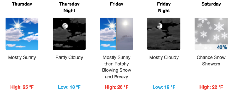
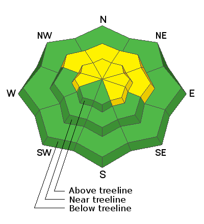
An isolated or MODERATE avalanche danger exists on steep, mid and upper elevation north facing slopes where triggering an avalanche on a buried persistent weak layer remains possible. The danger increases with elevation and slopes with evidence of recent wind loading are more suspect.
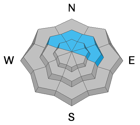
Most low elevation and south facing terrain has generally LOW danger.
It's also still very low tide out there. Beware of rocks, stumps, and deadfall lurking beneath the surface.
Low
Moderate
Considerable
High
Extreme
Learn how to read the forecast here
Weather and Snow
Get current and past 24-hour readings from these real-time weather links.
Snow totals and temps at Buckboard Flat (8924')
Snow totals and temps at Camp Jackson (8858')
Snowpack
Snow totals since last Friday are between 18" and 21" with locally higher amounts at upper elevations. Winds throughout the week have blown and drifted snow on to leeward aspects at mid and upper elevations. Northerly facing slopes above about 9500' have held snow since October, and this old snow has formed a weak, sugary, faceted layer at the base of the snowpack and this is where the trouble is. Recent and wind drifted snow has formed a dense slab over top of this weak, sugary snow and human triggered avalanches on steep, wind drifted slopes that face NW through E are possible. On slopes facing W and SE you may find unstable deposits of wind drifted snow. Wind drifts are recognizable by their smooth, rounded appearance and cracking is a sign of instability.
Avalanche Problem #1
Persistent Weak Layer
Type
Location
Likelihood
Size
Description
A classic setup of strong snow over weak snow is developing on upper elevation, northerly aspects that retained snow from October. This October snow has become loose, weak, and sugary, or as we say, faceted. This faceted snow has formed a persistent weak layer at the base of the snowpack. Recent and wind drifted snow has formed a dense slab on top of this weak snow creating an unstable situation, and human triggered avalacnhes up to 2' deep are likely on steep, northerly facing slopes at mid and upper elevations.
Extended column test illustrates the weak layer where a slab avalanche is likely to fail.
Avalanche Problem #2
Wind Drifted Snow
Type
Location
Likelihood
Size
Description
Blowing and drifting snow has formed new wind slabs on leeward slopes that face primarily NW through E, but the gusty, erratic behavior of the winds may have deposited snow on a variety of aspects. Look for fresh drifts on the leeward sides of terrain features such as sub ridges, gully walls, and rock outcroppings. Fresh drifts are recognizable by their smooth, rounded appearance, and cracking is a sign of instability. On northerly aspects, wind drifted snow has added stress to older slabs on top of a buried persistent weak layer and dangerous, human triggered avalanches 2'-3' deep are possible. Avoid steep, wind drifted slopes, especially those that face the north side of the compass.
General Announcements
Who's up for some free avalanche training? Get a refresher, become better prepared for an upcoming avalanche class, or just boost your skills. Go to https://learn.kbyg.org/ and scroll down to Step 2 for a series of interactive online avalanche courses produced by the UAC.
This forecast is from the U.S. Forest Service, which is solely responsible for its content. This forecast describes general avalanche conditions and local variations always occur.