Forecast for the Abajos Area Mountains

Eric Trenbeath
Issued by Eric Trenbeath on
Tuesday morning, January 21, 2020
Most terrain has generally LOW danger. With forecasted winds to remain relatively calm, the new snow should not change the danger much. Any increase in danger should be confined to the highest elevations where we may see some sensitive, shallow drifts forming in the new snow. An isolated or MODERATE danger exists on steep, upper elevation slopes that face NW-N-SE. The danger is generally isolated and spotty, with drifted areas existing between heavily scoured surfaces. Suspect slopes that have a smooth, rounded appearance or that feel and sound hollow like a drum.
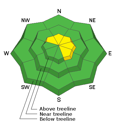
Low
Moderate
Considerable
High
Extreme
Learn how to read the forecast here
Special Announcements
We are very sad to report an avalanche fatality that happened on Saturday, January 18 above Farmington Canyon. An 18-year-old, male snowmobiler was caught, fully buried and killed. Preliminary info available HERE. forecasters re-visited the scene on Sunday, and we'll have a full report available in the coming days. Our deepest condolences go out to the friends, family, rescuers, and everyone affected by this tragic accident.
Our Backcountry 101 avalanche course has been scheduled for February 15, 16. The cost is $150. The course starts with a 4-hour classroom session the night of the 15th followed by a day in the field. It's a great way to increase your avalanche awareness and backcountry travel skills. Click here to register. A huge thanks to Moab Gear Trader for sponsoring this course. Please visit them for all your winter backcountry needs.
Weather and Snow
Look for snow showers in the mountains today as a short wave trough on a SW flow moves through the 4 Corners region. It's not a powerful system and it looks like 1"-3" are possible. Moderate to strong southerly winds overnight have backed off into the 10-15 mph range. They'll remain mostly light and shift to westerly later today. High temps at 10,000' will be near 30 degrees. The next shortwave will move through the region on Wednesday but will be too far north for us. Ridging and dry conditions develop through the weekend, with the crystal ball advertising a return to a more active pattern next week.
Upper elevation exposed slopes are wind damaged, but I'm getting reports of good, soft, settled powder conditions in sheltered locations.
Snow totals at Buckboard Flat (8924')
Snow totals at Camp Jackson (8858')
Wind, temperature, and humidity on Abajo Peak (11,000')
Recent Avalanches
General Announcements
This forecast is from the U.S. Forest Service, which is solely responsible for its content. This forecast describes general avalanche conditions and local variations always occur.