Forecast for the Abajos Area Mountains

Eric Trenbeath
Issued by Eric Trenbeath on
Saturday morning, January 18, 2020
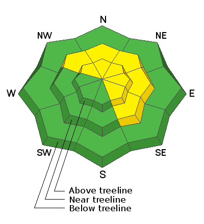
The avalanche danger is MODERATE at mid and upper elevations on steep, wind drifted slopes that face NW-N-SE. Look for shallow drifts in the most recent snow that could become problematic if more than about 6" deep. In some cases, fresh drifts may cover older wind slabs that formed earlier in the week. Suspect slopes that have a smooth, rounded appearance or that feel and sound hollow like a drum. Non-wind loaded slopes have generally LOW danger.
Low
Moderate
Considerable
High
Extreme
Learn how to read the forecast here
Special Announcements
Our Backcountry 101 avalanche course has been scheduled for February 15, 16. The cost is $150. The course starts with a 4-hour classroom session the night of the 15th followed by a day in the field. It's a great way to increase your avalanche awareness and backcountry travel skills. Click here to register. A huge thanks to Moab Gear Trader for sponsoring this course. Please visit them for all your winter backcountry needs.
Weather and Snow
A fast but intense period of snow and wind moved through yesterday morning bringing 4" of snow to the mountains. Strong SW winds cranked through the morning before backing off and shifting to the NW around noon. This morning, skies are clear, temps are cold, and NW winds are light. A dirty ridge of high pressure will build over the area, bringing dry and calm conditions through the weekend. A weak, mid-level trough will bring unsettled conditions Tue-Wed. Models haven't come up with a consistent solution yet, but it's not looking like much either way.
Snow totals at Buckboard Flat (8924')
Snow totals at Camp Jackson (8858')
Wind, temperature, and humidity on Abajo Peak (11,000')
Recent Avalanches
General Announcements
This forecast is from the U.S. Forest Service, which is solely responsible for its content. This forecast describes general avalanche conditions and local variations always occur.