Conditions in the Abajos remain dangerous. Travel advice is to avoid avalanche terrain and stick to slopes under 30 degrees with no steep slopes above you.
Snowpack Summary and General Conditions
A weak storm will affect our area today and tomorrow. While this event will mostly bring strong winds, we should see some light snow accumulations. Camp Jackson has picked up three inches so far. Snow will be light today with another 2-4 possible overnight. Strong SW winds will be whipping up fresh slabs of wind drifted snow. This will be a concern, especially if snow totals exceed forecasted amounts. Backcountry travelers should avoid fat rounded pillows of wind drifted snow.
Two feet of heavy wet snow fell in the Abajos over New Year's weekend. Prior to this storm, the Abajo range had a shallow, weak snowpack with facets near the ground. The heavy snow buried this weak snowpack structure and produced a round of natural avalanche activity. Last week I got eyes on some big avalanches that occurred on East aspects. These slides took out the entire season snowpack running on a hard crust at the ground. Stability tests continue to produce failures on this same weak layer. Slopes that face NW-N-NE-E will be the most dangerous, but the overall snowpack in the Abajos remains weak and precarious. Stick to low angle slopes and meadows if you are out recreating in the mountains.
This short video clip shows the full track of an avalanche that overran the switchbacks on the summer road up North Creek. The debris piled up in the creek bed at the bottom. This road is a popular route for snowmobiles.
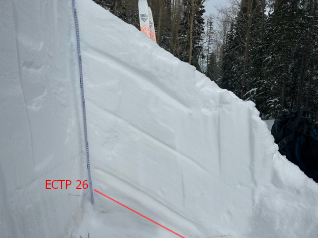
The avalanche in the video failed on facets on top of a hard crust at the ground. The weak layer of facets is represented by the red line in this photo. It is easy to see how an avalanche failing on this layer would take out the entire season's snowpack, resulting in a deep and deadly avalanche.