| During the month of April, Mark Miller will donate $75 to the charity of your choice (5 to chose from, including the Utah Avalanche Center!) Mark Miller Subaru has raised over $300k in the previous 6 Do Good Feel Good events. More Info here |  |

For every car Mark MIller Subaru sells in April, they will donate $75 to the charity of your choice (5 to choose from). Who are you going to choose? Plus - you can vote for your favorite and the 3 groups receiving the most votes get an additional cash prize donated by Mark Miller Subaru. Details here

| During the month of April, Mark Miller will donate $75 to the charity of your choice (5 to chose from, including the Utah Avalanche Center!) Mark Miller Subaru has raised over $300k in the previous 6 Do Good Feel Good events. More Info here |  |
| Advisory: Uintas Area Mountains | Issued by Craig Gordon for Tuesday - March 24, 2015 - 5:25am |
|---|
 |
current conditions Skies are clear this morning in the wake of a nice little storm that delivered 6" of medium density snow to the eastern front. Winds have been all over the place, but this morning they're west and northwest, blowing 25-40 mph along the ridges. It'll feel like winter with temperatures in the teens and low 20's. Riding and turning conditions vastly improved in the past 24 hours and low angle slopes will be the ticket to avoid bottoming out on the old, hard, preexisting snow surfaces. Click here for real-time temperatures, snowfall, and winds.
|
 |
recent activity No new avalanche activity to report. |
| type | aspect/elevation | characteristics |
|---|


|


|

LIKELIHOOD
 LIKELY
UNLIKELY
SIZE
 LARGE
SMALL
TREND
 INCREASING DANGER
SAME
DECREASING DANGER
|
|
description
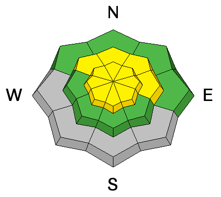
Today's main avalanche problem are the fresh drifts recent winds whipped up along the leeward side of upper elevation ridges. Yesterday, southwest winds cranked 30-50 mph til just about sunset, then switched to the west and northwest, dying down a bit, but still pretty burly in the 30's and 40's. These wind speeds along with plenty of snow to blow around are the perfect slab building combo. It's not a total no-brainer out there today as winds have been all over the compass, though primarily loading slopes with an easterly component to their aspect. Not only will you find fresh slabs sensitive to your additional weight near the ridges, but also around terrain features like chutes, gullies, and sub-ridges. Today you'll want to look for and avoid any fat looking rounded piece of snow, especially if it sounds hollow like a drum.
|
 |
weather A break in the action this morning with sunny skies and temperatures rising into the low 30's. Clouds and westerly winds increase throughout the day and it'll be blowing in the 40's and 50's as another wave of moisture slides through the region late in the day. We can expect an additional 3"-6" of snow overnight with temperatures dipping into the teens. Winds die down for Wednesday and we dry out as high pressure builds. A warming trend is on tap for the latter half of the week.
|
| general announcements Remember your information can save lives. If you see anything we should know about, please participate in the creation of our own community avalanche advisory by submitting snow and avalanche conditions. You can call me directly at 801-231-2170, email craig@utahavalanchecenter.org, or email by clicking HERE This is a great time of year to schedule a free avalanche awareness presentation for your group or club. You can contact me at 801-231-2170 or email craig@utahavalanchecenter.org Donate to your favorite non-profit –The Utah Avalanche Center. The UAC depends on contributions from users like you to support our work. Benefit the Utah Avalanche Center when you buy or sell on ebay - set the Utah Avalanche Center as a favorite non-profit in your ebay account here and click on ebay gives when you buy or sell. You can choose to have your seller fees donated to the UAC, which doesn't cost you a penny. Utah Avalanche Center mobile app - Get your advisory on your iPhone along with great navigation and rescue tools. The information in this advisory is from the US Forest Service which is solely responsible for its content. This advisory describes general avalanche conditions and local variations always occur. I will update this advisory by 7:00 AM Wednesday Mar. 25, 2015 or sooner if conditions warrant. |
Advisory Hotline: (888) 999-4019 | Contact Information