

| Advisory: Uintas Area Mountains | Issued by Craig Gordon for November 28, 2012 - 6:35am |
|---|


Above treeline
Near treeline
Below treeline
|
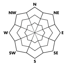
bottom line Terrain to avoid- steep, upper elevation, north facing slopes above treeline where fresh wind drifts may be stubborn, but once triggered, they could take you for a season ending ride through rocks, stumps, and trees. LOW avalanche danger exists on wind sheltered slopes.
|
 |
special announcement Mirror Lake Highway is closed and plowing is done for the season. Wolf Creek Pass remains open, but don't let the easy access to nearby terrain lull you into a false sense of security. Be prepared for your own self rescue. Wear and know how to use a beacon, shovel, and probe. |
 |
current conditions Under partly cloudy skies, temperatures remain inverted with trailhead readings in the mid 20's and ridgetops hovering right around freezing. Southwest winds ramped up over night and are blowing 15-25 mph along the ridges and into the 40's near the high peaks. Man... it's looking a little grim out there. Down low most of our early season snow is gone and the sunny slopes are bare. On the other side of the coin, much of the upper elevation wind exposed terrain got nuked during last Wednesday's wind event and now resembles a moonscape. Somewhere in between however, among all the variable conditions, there may be a patch or two of soft settled snow on wind sheltered slopes facing the north half of the compass. Recent snow and avalanche observations can be found here. Wondering why last winter was so crazy? Click here to watch the 2011-12 Utah Winter Review... an excellent recap of last years conditions. |
 |
recent activity No recent avalanche activity to report. |
| type | aspect/elevation | characteristics |
|---|
 |


Above treeline
Near treeline
Below treeline
|
|
|
description
Today's gusty upper elevation winds may find enough loose snow to blow around and form a fresh wind slab or two. However, you'd really have to go out of your way to trigger an avalanche today. If you're travels take you to steep, upper elevation terrain facing the north half of the compass, you'll want to continue avoiding any recent deposits of wind drifted snow. These will appear fat and rounded and often sound hollow like a drum. Given the thin snow cover and all the obstacles barely hidden under the snow, triggering even a small slide could have body beating consequences. |
 |
weather A mild southwest flow develops across the region today. We should see increasing high clouds, southwest winds gusting into the 40's along the high ridges, and temperatures climbing into the mid 30's. A weak weather system brushes by the area tonight bringing a slight chance of snow, with another system sliding through late Friday. Most of the energy stays north of us, so I don't expect much accumulation. Sunday we should see a change in the weather pattern as a moist trough begins to move over the region. This looks like a much needed high density snow event and I hope to have more details on strength and timing for Saturday's update. |
| general annoucements Remember your information can save lives. If you see anything we should know about, please participate in the creation of our own community avalanche advisory by submitting snow and avalanche conditions. You can call me directly at 801-231-2170, email craig@utahavalanchecenter.org, or email by clicking HERE This is a great time of year to schedule a free avalanche awareness presentation for your group or club. You can contact me at 801-231-2170 or email craig@utahavalanchecenter.org Donate to your favorite non-profit –The Friends of the Utah Avalanche Center. The UAC depends on contributions from users like you to support our work. The information in this advisory is from the US Forest Service which is solely responsible for its content. This advisory describes general avalanche conditions and local variations always occur. The information in this advisory expires 24 hours after the date and time posted, but will be updated by 7:00 AM Saturday December 1st. |