25th Annual Black Diamond Fall Fundraising Party
Thursday, September 13; 6:00-10:00 PM; Black Diamond Parking Lot
25th Annual Black Diamond Fall Fundraising Party
Thursday, September 13; 6:00-10:00 PM; Black Diamond Parking Lot
| Advisory: Skyline Area Mountains | Issued by Brett Kobernik for Saturday - March 10, 2018 - 6:55am |
|---|

|
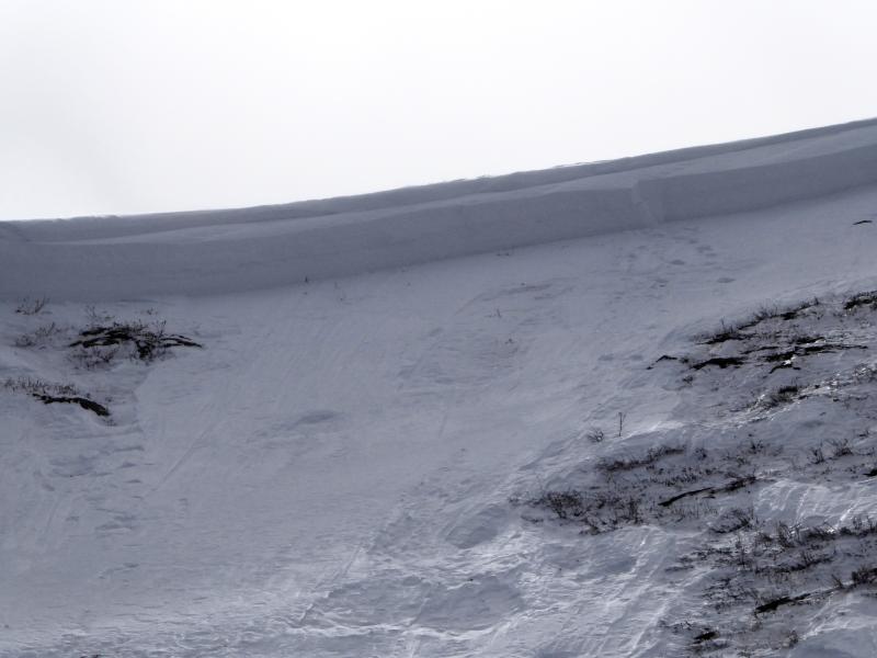
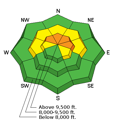
bottom line The majority of the terrain along the Skyline has a LOW to MODERATE avalanche danger and most people can travel and recreate safely today. However, a CONSIDERABLE danger still exists in the upper elevation slopes steeper than about 35 degrees that face northwest, north and east. Human triggered avalanches are likely today in this terrain.
|
 |
current conditions Last weekend's storm brought 8 to 11 inches of new snow to the Skyline. Southwest wind following the storm drifted a significant amount of snow. We've seen warmer temperatures over the last few days. This has not effected the avalanche conditions much. All the warm temps have done is settle the new snow and make it damp on the sunny facing slopes and all aspects in the mid and lower elevations. This morning we have mountain temperatures in the mid 20s, light west wind and a few scattered clouds. |
 |
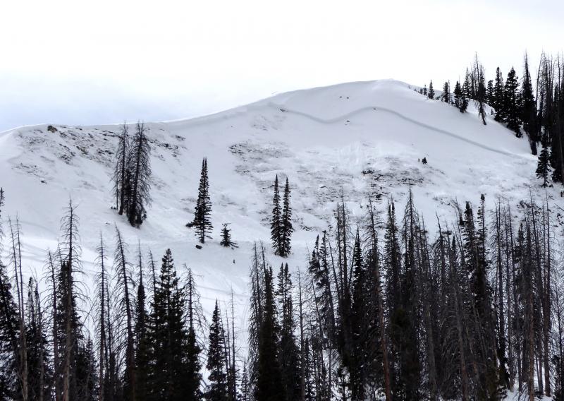
recent activity Last weekend's storm was finally enough to tip the balance of the weak snowpack we have. Avalanches have been breaking to the ground and are large enough to be very dangerous. Here is a list of significant avalanches that I know of which have released in the Skyline region recently:
The most recent one I found was in the north fork of Lake Canyon. This appears to have been snowmobile triggered. What is important about this is that there are MANY more slopes exactly like this that haven't avalanched and just need a trigger in the right spot to release.
|
| type | aspect/elevation | characteristics |
|---|
|
|
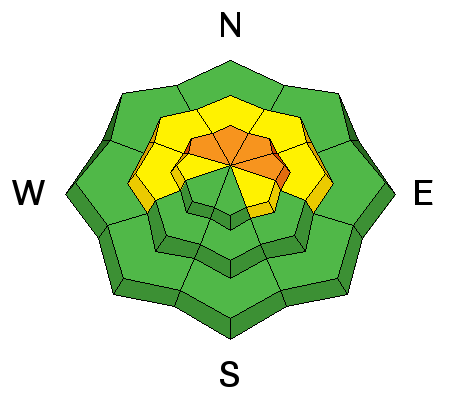
LIKELIHOOD
 LIKELY
UNLIKELY
SIZE
 LARGE
SMALL
TREND
 INCREASING DANGER
SAME
DECREASING DANGER
|
|
description
If a person gets onto steep slopes that face northwest, north or east, buried weak snow near the ground is still likely to collapse and cause avalanches. The snowpack is more stubborn now compared to earlier in the week so you may be able to get onto a number of slopes before one avalanches on you. This makes things trickier. The key is to continue to avoid those steep slopes that I mentioned. |
 |
weather It looks like a pretty nice day ahead with partly cloudy skies, mountain temperatures in the low 30s and light northwest wind. A minor weather disturbance will move through tonight with no snow accumulations expected. Sunday will be cloudy but perhaps clearing later in the afternoon. High temperatures will be around 30 and we'll have light wind from the east. High pressure settles in for early in the week and a larger storm is shaping up for later in the week. |
| general announcements Support the Utah Avalanche Center through your everyday shopping. DETAILS HERE We will publish full detailed advisories Saturday and Sunday mornings by 7am. We will also be publishing basic avalanche danger ratings & info during the week. If you are getting out into the mountains, we love to hear from you! You can SUBMIT OBSERVATIONS ONLINE or EMAIL US If you would like to have avalanche advisories emailed to you, SIGN UP HERE We can provide basic avalanche awareness presentations for your school, group or club. To enquire, CLICK HERE |