25th Annual Black Diamond Fall Fundraising Party
Thursday, September 13; 6:00-10:00 PM; Black Diamond Parking Lot
25th Annual Black Diamond Fall Fundraising Party
Thursday, September 13; 6:00-10:00 PM; Black Diamond Parking Lot
| Advisory: Skyline Area Mountains | Issued by Brett Kobernik for Saturday - January 20, 2018 - 5:50am |
|---|

|
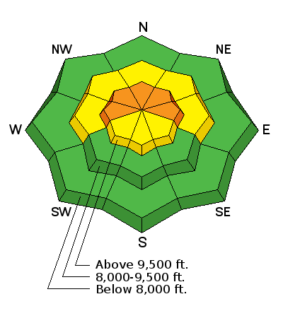
bottom line The avalanche danger starts out at MODERATE this morning and will most likely increase to CONSIDERABLE by this afternoon if the storm produces any significant new snow. Steep upper elevation west, north and east facing slopes should be avoided. The weight of the new snow today may overload the buried weak faceted "sugary" snow near the ground.
|
 |
special announcement Be sure to join us at Big Pine Sports on Thursday, January 25th for a free avalanche presentation. DETAILS HERE We are offering a Motorized Backcountry 101 avalanche class on February 10th. DETAILS HERE |
 |
current conditions Temperatures over the last few days have been unseasonably warm. On Friday, the snow surface became damp on all aspects up to 9500'. This should make for supportable travel conditions once the damp snow freezes up. The snow above 9500' remained cold and will still be loose and somewhat unsupportable in many locations still. Temperatures remain fairly warm this morning with most upper elevation stations in the 25 to 30˚ range. Ridgetop wind has been from the southwest. It was a bit stronger on Friday compared to this morning where we are seeing moderate speeds. No new snow has fallen yet as the storm coming from the northwest is slow to make it's way through the center part of the state. |
| type | aspect/elevation | characteristics |
|---|
|
|
LIKELIHOOD
 LIKELY
UNLIKELY
SIZE
 LARGE
SMALL
TREND
 INCREASING DANGER
SAME
DECREASING DANGER
|
|
description
Avalanches breaking into old snow near the ground today will depend on how much new snow we get. I suspect that this storm isn't going to really add enough weight to produce significant widespread avalanche activity. That said, the steep upper elevation west, north and east facing slopes is where you will find trouble today as the new snow stacks up. With how weak the snow is near the ground, it's best to not mess with these slopes. Side note: It will be interesting to see how Friday's warm temperatures and damp snow effects the overall snow structure in terrain below 9500'. It should be a good thing as the damp snow should turn into a very strong layer once it freezes. However, the weak faceted snow near the ground was still cold and will remain loose and sugary. Once the damp snow freezes up, will it "bridge" the weak snow near the ground and make a stable snowpack? Time will tell, stay tuned! |
 |
weather We'll see snow today with ridge top temperatures dropping to around 20˚F. Ridgetop wind will be light to moderate from the southwest and gradually veer to the northwest later today. I'm optimistically thinking we'll see 6 to 10" of new snow by the time the storm moves out on Sunday. It looks like the north wind is going to increase in speed on Sunday which could increase the avalanche danger. |
| general announcements Support the Utah Avalanche Center through your everyday shopping. DETAILS HERE We will publish full detailed advisories Saturday and Sunday mornings by 7am. We will also be publishing basic avalanche danger ratings & info during the week. If you are getting out into the mountains, we love to hear from you! You can SUBMIT OBSERVATIONS ONLINE or EMAIL US If you would like to have avalanche advisories emailed to you, SIGN UP HERE We can provide basic avalanche awareness presentations for your school, group or club. To enquire, CLICK HERE |