25th Annual Black Diamond Fall Fundraising Party
Thursday, September 13; 6:00-10:00 PM; Black Diamond Parking Lot
25th Annual Black Diamond Fall Fundraising Party
Thursday, September 13; 6:00-10:00 PM; Black Diamond Parking Lot
| Advisory: Skyline Area Mountains | Issued by Brett Kobernik for Sunday - December 24, 2017 - 5:45am |
|---|

|
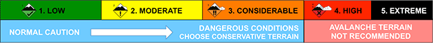
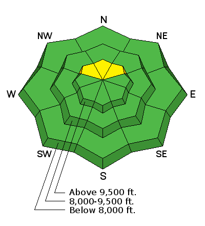
bottom line The avalanche danger is generally LOW on the majority of the terrain along the Skyline. There is a slight chance that a person might trigger a pocket on the steep north facing slopes above about 9500' where a pockety MODERATE danger exists. These won't be large avalanches but even a small one would not be good to take a ride in due to such shallow cover over the rocks and logs.
|
 |
current conditions Only a skiff of snow fell during Saturday's minor storm. The west wind was blowing fairly strong along the ridges and was getting down into the canyon bottoms also. Temperatures cooled down into the teens and the wind has slowed a bunch except in the more exposed locations where it is still in the moderate speed range. There is not really enough snow along the Skyline for recreating on skis, snowboards or snowmobiles yet. I spoke with someone who rode their sled up one of the canyons and he reported his skis were sinking right through the low density snow and grinding gravel most of the way up. |
| type | aspect/elevation | characteristics |
|---|
|
|
LIKELIHOOD
 LIKELY
UNLIKELY
SIZE
 LARGE
SMALL
TREND
 INCREASING DANGER
SAME
DECREASING DANGER
|
|
description
Weak snow from October and November has formed on the north facing slopes above about 9500'. The recent storm didn't overload this weak snow. The recent west wind might have transported enough of the new low density powder creating some pockets that might release if provoked. These avalanches won't be all that big but could ruin your day nonetheless. It's a "Catch 22" because these upper elevation north facing slopes are exactly where we want to go since they are holding the most snow right now. Approach these slopes with caution. It's a much different winter compared to last winter so far. |
 |
weather We'll see clouds moving in today as the day progresses ahead of the next little storm. Ridge top high temperatures will be in the mid 20s and west wind will be in the moderate speed range. The storm that will roll through tonight looks fairly windy with temperatures remaining in the 20s. I'm thinking we might see 3 to 6" by Christmas Day. It's not much be we'll take anything we can at this point! The latest model runs do make tonights storm look a bit better for our region. For next week, I don't see anything except a minor disturbance brushing the north half of the state on Saturday. We'll hope for better in 2018! |
| general announcements We will publish full detailed advisories Saturday and Sunday mornings by 7am. We will also be publishing basic avalanche danger ratings & info during the week. If you are getting out into the mountains, we love to hear from you! You can SUBMIT OBSERVATIONS ONLINE or EMAIL US If you would like to have avalanche advisories emailed to you, SIGN UP HERE We can provide basic avalanche awareness presentations for your school, group or club. To enquire, CLICK HERE |