25th Annual Black Diamond Fall Fundraising Party
Thursday, September 13; 6:00-10:00 PM; Black Diamond Parking Lot
25th Annual Black Diamond Fall Fundraising Party
Thursday, September 13; 6:00-10:00 PM; Black Diamond Parking Lot
| Advisory: Skyline Area Mountains | Issued by Brett Kobernik for Sunday - January 22, 2017 - 6:58am |
|---|

|
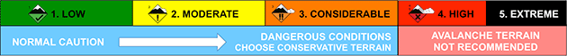
bottom line The avalanche danger is MODERATE in the mid and upper elevation terrain on slopes steeper than 35 degrees. Human triggered avalanches are possible especially in areas where the wind has been drifting snow. Anticipate the avalanche danger to rise during the next windy storm scheduled for later today and through Monday.
|
 |
special announcement If you sign up for AmazonSmile and designate the Utah Avalanche Center as your favorite charity, they will donate a portion of everything you spend to the UAC. It doesn't cost you a penny and we'd really appreciate the help. |
 |
current conditions The mountains received another 3 to 5 inches of snow in the last 24 hours. The northwest wind on Saturday was a little stronger than I anticipated and was definitely drifting snow along the ridges and getting down into the mid portions of the canyons as well. Along some mid elevation exposed ridges, we found the fresh drifts to be only somewhat sensitive. We were able to get some cracking when we poked at them but nothing sheared and released. I suspect along higher and steeper terrain, things would've been more serious. The wind has let up for the time being and is from the west. Mountain temperatures are in the mid teens. |
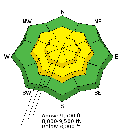
| type | aspect/elevation | characteristics |
|---|

|
|
LIKELIHOOD
 LIKELY
UNLIKELY
SIZE
 LARGE
SMALL
TREND
 INCREASING DANGER
SAME
DECREASING DANGER
|
|
description
Freshly formed wind drifted snow will be your main concern today. These drifts will not be as sensitive as they were late Saturday but may still crack out and surprise you. Continue to hit many small steep test slopes (with no consequences) to see if you can initiate any cracking of the newly formed drifts. This will give you a good idea of how sensitive things are. Today's southwest wind may start to form more drifts as the wind increases later today. Drop me a line and let me know if you are experiencing any cracking or if you find things to be stable. |
 |
weather We'll have mostly cloudy skies today with snow likely this afternoon. We probably won't see much accumulation until this evening. Southwest wind will start to increase as the day goes on. Temperatures will be in the low 20s. Southwest wind will get strong tonight and into Monday when the majority of the snow will fall. Most weather models are advertising about an inch of water which would translate into around a foot of snow for our area through Monday. The European model, however, is coming in with only around .5" of water which would be around 6 inches. I'm anticipating that we'll see totals somewhere in between. |
| general announcements We will publish full detailed advisories Saturday and Sunday mornings by 7am. We will also be publishing basic avalanche danger ratings & info during the week. If you are getting out into the mountains, we love to hear from you! You can SUBMIT OBSERVATIONS ONLINE or EMAIL US If you would like to have avalanche advisories emailed to you, SIGN UP HERE We can provide basic avalanche awareness presentations for your school, group or club. To enquire, CLICK HERE |