25th Annual Black Diamond Fall Fundraising Party
Thursday, September 13; 6:00-10:00 PM; Black Diamond Parking Lot
25th Annual Black Diamond Fall Fundraising Party
Thursday, September 13; 6:00-10:00 PM; Black Diamond Parking Lot
| Advisory: Skyline Area Mountains | Issued by Brett Kobernik for Saturday - December 17, 2016 - 6:28am |
|---|

|
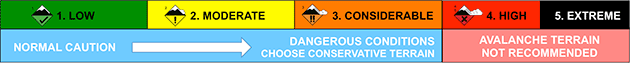
bottom line The avalanche danger is CONSIDERABLE today. Human triggered avalanches are likely ESPECIALLY ON UPPER ELEVATION NORTH THROUGH EAST FACING STEEP SLOPES. Give the snowpack a little time to adjust to it's new load before hitting the steep slopes.
|
 |
special announcement There will be a free avalanche presentation at the Emery County Search and Rescue building in Castledale on Monday, December 19. The public is welcome. DETAILS HERE |
 |
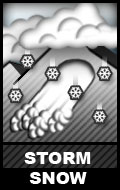
current conditions Well that was an intense storm! The southwest wind howled on Friday with warm temperatures and the rain/snow line up around 8000' in elevation. Around 9 inches of dense heavy snow fell during the morning and afternoon in the higher elevations. It measured almost 20% density! Then the cold front moved through at around 3pm with a short period of graupel, lightning and thunder. After the frontal passage, the winds shifted to the northwest and decreased dramatically. The temperature also dropped. Snow dropped to the valley floor. A period of intense snowfall then lasted through most of the night adding another 10" of much lower density snow. You'll find 15 to 20" of new snow out there today with temperatures in the single digits right now. The northwest wind is fairly well behaved currently. Riding condtions should be excellent today but use your head. Below is a video of a storm board at 9400'. The marks are 2" increments. This shows about 20" of snow accumulation in 24 hours. |
 |
recent activity Visibility was poor yesterday so it was impossible to see if there was any natural avalanche activity occurring. I would be surprised if there wasn't any where the wind was really drifting the snow along the ridges. |
| type | aspect/elevation | characteristics |
|---|
|
|
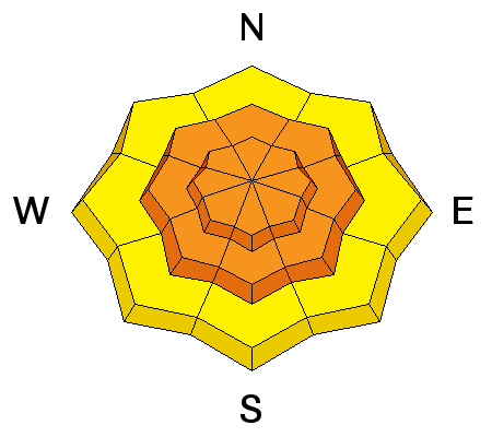
LIKELIHOOD
 LIKELY
UNLIKELY
SIZE
 LARGE
SMALL
TREND
 INCREASING DANGER
SAME
DECREASING DANGER
|
|
description
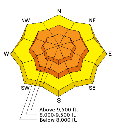
The most likely spot to trigger an avalanche today is along the higher terrain on north through east facing slopes steeper than about 35 degrees. This is where the wind has been depositing snow into deep drifts. These still may be sensitive to the weight of a person today. |
| type | aspect/elevation | characteristics |
|---|
|
|
LIKELIHOOD
 LIKELY
UNLIKELY
SIZE
LARGE
SMALL
TREND
INCREASING DANGER
SAME
DECREASING DANGER
|
|
description
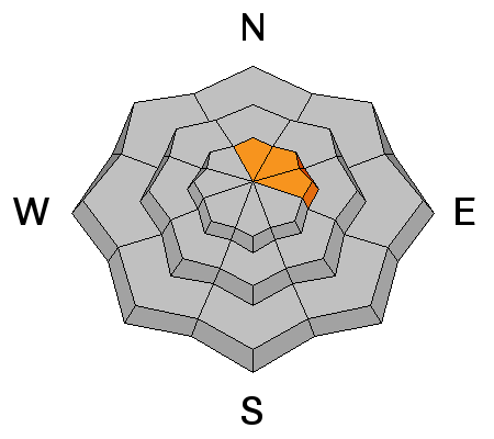
Since a lot of the snow fell late in the afternoon and overnight, we don't really know how it is behaving. My best guess is that it is mostly stable outside of the more wind effected areas. However, we need to treat the new snow as guilty until proven innocent. Approach the backcountry cautiously today. Use steep "test slopes" that don't have any serious consequences to see if the snow is cracking at all. Look around for recent natural avalanches. Don't just jump into the first steep slope you come to. With a little time, the snowpack should become quite stable. Have a little patience today. |
 |
weather The storm will continue to wind down today. Temperatures are going to be cold today with ridgetop highs only around 10 degrees. Northwest wind should be light to moderate in speed but perhaps just a bit gusty along the higher ridges. We should have partly cloudy skies as the day progresses. Sunday looks like a clear day with slightly warmer temperatures. The long term weather pattern looks active still with numerous storms through the end of the month. The next small one looks to roll through mid week or so. |
| general announcements We will publish full detailed advisories Saturday and Sunday mornings by 7am. We will also be publishing basic avalanche danger ratings & info during the week. If you are getting out into the mountains, we love to hear from you! You can SUBMIT OBSERVATIONS ONLINE or EMAIL US If you would like to have avalanche advisories emailed to you, SIGN UP HERE We can provide basic avalanche awareness presentations for your school, group or club. To enquire, CLICK HERE |