| Please join us at the 23rd annual Black Diamond Fall Fundraiser Party Thursday Sept 15. Tickets are on sale now here, at the Black Diamond store & at REI. Special bonus raffle for online ticket purchasers! |
| Please join us at the 23rd annual Black Diamond Fall Fundraiser Party Thursday Sept 15. Tickets are on sale now here, at the Black Diamond store & at REI. Special bonus raffle for online ticket purchasers! |
| Advisory: Skyline Area Mountains | Issued by Brett Kobernik for Sunday - February 21, 2016 - 6:07am |
|---|

|
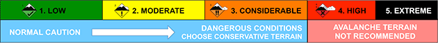
bottom line Overall, the avalanche danger is slightly lower than it was on Saturday. However, that's not enough for me trust those shallow high north through east facing steep slopes. A MODERATE danger still exists for triggering an avalanche that breaks to the ground. If you avoid those steep upper elevation north through east facing slopes, the avalanche danger is generally LOW. If you really want to get into the upper elevation north through east facing terrain, keep the slope angles under 35 degrees and this will lesson your chances dramatically of triggering something.
|
 |
current conditions Temperatures on Saturday were just a few degrees cooler along the highest ridgelines compared to Friday. East, south and west facing slopes became damp due to the direct sun. Overnight temperatures dropped into the mid to low 20s. You'll find a melt freeze crust on the surface in a lot of the terrain out there this morning. North northwest wind on Saturday was just slightly stronger than Friday but now has really dropped off. Some snow was being transported along the upper ridges but nothing too significant. |
 |
recent activity I made an error in reporting an avalanche in the advisory on Saturday. I mistakenly wrote that it was in Rolfson. It was actually in Jordan Canyon. No new avalanches were reported from Saturday. If you ever trigger or see avalanches that have released please let us know so we can pass along the info to the rest of our community. It is some of the most important info that we can get to help us all stay safe. THANK YOU!!! |
| type | aspect/elevation | characteristics |
|---|

|
|
LIKELIHOOD
 LIKELY
UNLIKELY
SIZE
 LARGE
SMALL
TREND
 INCREASING DANGER
SAME
DECREASING DANGER
|
|
description
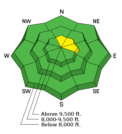
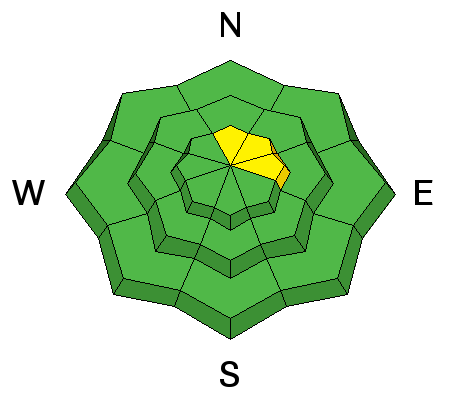
Really, the only significant avalanche concern out there is the same thing we've been dealing with since December. North, northeast and east facing slopes that have already avalanched earlier this season remain suspect today. After each weather event where we receive some snow and wind, the sensitivity of these slopes increases and we see a couple of human triggered avalanches after each event. As time passes after each storm, the snowpack gradually settles and it becomes less likely to trigger something. This is the case for today. It is less likely you'll trigger something today compared to Saturday but the possibility still exists. |
 |
weather Weather today looks similar to what we saw on Saturday. Ridgetop high temperatures will reach the low to mid 30s and we'll see mostly clear skies. West northwest wind will be fairly light today with a slight increase as the day goes on. A minor storm scheduled for Monday into Tuesday looks pretty unimpressive. It will perhaps deliver a few inches of snow. After that, I'm not seeing anything in the long range weather models that really even qualifies as a "refresher" at this time. |
| general announcements We will publish full detailed advisories Saturday and Sunday mornings by 7am. We will also be publishing basic avalanche danger ratings & info during the week. If you are getting out into the mountains, we love to hear from you! You can SUBMIT OBSERVATIONS ONLINE or EMAIL US If you would like to have avalanche advisories emailed to you, SIGN UP HERE We can provide basic avalanche awareness presentations for your school, group or club. To enquire, CLICK HERE |