| Please join us at the 23rd annual Black Diamond Fall Fundraiser Party Thursday Sept 15. Tickets are on sale now here, at the Black Diamond store & at REI. Special bonus raffle for online ticket purchasers! |
| Please join us at the 23rd annual Black Diamond Fall Fundraiser Party Thursday Sept 15. Tickets are on sale now here, at the Black Diamond store & at REI. Special bonus raffle for online ticket purchasers! |
| Advisory: Skyline Area Mountains | Issued by Brett Kobernik for Saturday - January 30, 2016 - 6:48am |
|---|

|
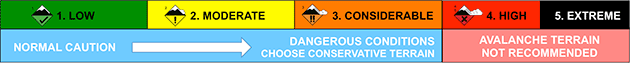
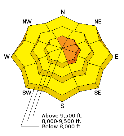
bottom line THE AVALANCHE DANGER WILL BE INCREASING AS THE STORM ARRIVES LATER TODAY. A CONSIDERABLE avalanche danger exists along the higher north through southeast facing steep terrain where human triggered avalanches are likely that could break to the ground. Also, avoid very steep terrain in the lower elevations until the snowpack cools down again. There will likely be a HIGH danger on Sunday.
|
 |
current conditions There was a rain-snow mix happening late in the day on Friday with the rain-snow line somewhere around 8000 feet. Temperatures have actually increased overnight which will push that rain-snow line up perhaps to 9000 feet. The snowpack is quite wet in the lower elevations. It was slightly breezy along the ridges on Friday and the winds have bumped in speed slightly overnight. They are generally from the west. |
| type | aspect/elevation | characteristics |
|---|
|
|
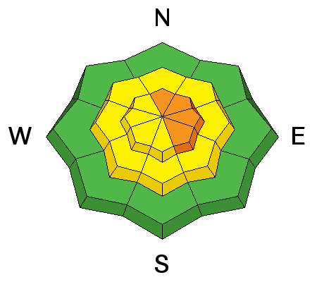
LIKELIHOOD
 LIKELY
UNLIKELY
SIZE
 LARGE
SMALL
TREND
 INCREASING DANGER
SAME
DECREASING DANGER
|
|
description
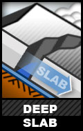
The weak snow that is near the ground and another layer in the middle of the snowpack is my biggest concern. Wind transporting snow during the day today may increased the chances of triggering a deep avalanche breaking into these layers. The danger will continue to increase as we start to add snow late today. |
| type | aspect/elevation | characteristics |
|---|
|
|
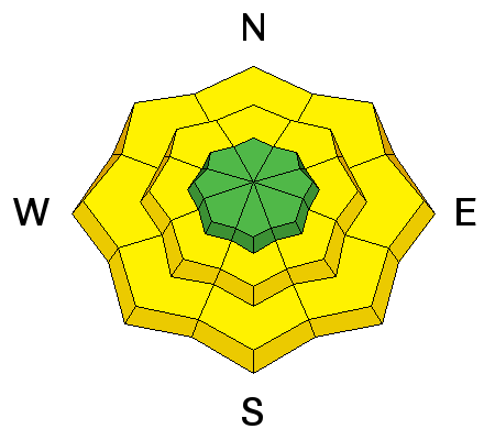
LIKELIHOOD
 LIKELY
UNLIKELY
SIZE
LARGE
SMALL
TREND
 INCREASING DANGER
SAME
DECREASING DANGER
|
|
description
Rain on snow can make the snowpack do strange things sometimes. It can produce avalanches where we don't usually see them. I would avoid very steep lower elevation terrain today where the snowpack is damp and saturated. Especially avoid being in the bottom of gullies where a natural avalanche from above may funnel into it. Sometimes we don't see any avalanche activity due to the wet snow but it certainly is a clue that should be taken into account. |
 |
weather I am not as excited about this storm as I once was. The cold front will slowly sag through the state from the north and arrive in our area late afternoon or early evening. We should see an intense period of snowfall during this time. Wind speeds should increase and be quite strong from the west today. Temperatures will remain mild through most of the day. I'm expecting 6 to 10 inches of snow by Sunday morning. A secondary system is going to move through southern Utah starting mid day Sunday. It looks to me like it's a bit too far south to give us huge amounts of snow but we'll hopefully see a few more inches out of it. |
| general announcements We will publish full detailed advisories Saturday and Sunday mornings by 7am. We will also be publishing basic avalanche danger ratings & info during the week. If you are getting out into the mountains, we love to hear from you! You can SUBMIT OBSERVATIONS ONLINE or EMAIL US If you would like to have avalanche advisories emailed to you, SIGN UP HERE We can provide basic avalanche awareness presentations for your school, group or club. To enquire, CLICK HERE |