| Please join us at the 23rd annual Black Diamond Fall Fundraiser Party Thursday Sept 15. Tickets are on sale now here, at the Black Diamond store & at REI. Special bonus raffle for online ticket purchasers! |
| Please join us at the 23rd annual Black Diamond Fall Fundraiser Party Thursday Sept 15. Tickets are on sale now here, at the Black Diamond store & at REI. Special bonus raffle for online ticket purchasers! |
| Advisory: Skyline Area Mountains | Issued by Brett Kobernik for Sunday - January 3, 2016 - 6:45am |
|---|

|
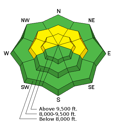
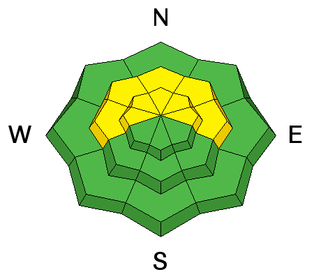
bottom line Lower elevation terrain has generally a LOW avalanche danger. There is a MODERATE avalanche danger in the mid and upper elevation steep terrain. The danger is most pronounced along the high ridges on slopes that face west, northwest and north but watch northeast and east facing slopes today as well. Human triggered avalanches are possible. In the right spot, these avalanches could be quite dangerous.
|
 |
special announcement We continue to have technical difficulties with our web hosting company. We apologize for the inconsistent website connections over the past week. |
 |
current conditions Temperatures are quite mild in the high country this morning with upper elevation readings in the upper 20s to low 30s. Wind speeds are light to moderate from the south. |
 |
recent activity The east wind on Friday transported enough snow to produce some natural avalanche activity. These slides were not all that large and didn’t pose that much of a threat. There was at least one pocket that was triggered by a snowmobiler on Saturday near the Skyline Summit along SR31. It was on a high elevation northwest facing slope that had a recent fresh drift form on it. It was a very small and confined pocket that popped out which didn’t pose much threat.
|
| type | aspect/elevation | characteristics |
|---|

|
|
LIKELIHOOD
 LIKELY
UNLIKELY
SIZE
 LARGE
SMALL
TREND
 INCREASING DANGER
SAME
DECREASING DANGER
|
|
description
The biggest concern today is finding one of these recent wind drifts that has formed on top of an area that has old weak snow from early November. Most likely locations for this are on upper elevation west, northwest and north facing steep slopes along the ridges. You may find these drifts on slopes that face other directions as well due to wind swirling around. This is a "low probability" but "high consequence" situation. Use caution in the high terrain today. |
 |
weather Mild temperatures and light to moderate south wind with mostly cloudy skies is what’s in store today. Wind direction may be slightly from the southeast. It’s looking like a series of small storms will give us some snow during the upcoming week. Totals don’t look huge at this time but it will be enough to freshen up riding conditions. It looks like we’ll see a few inches on Tuesday and then a slightly stronger impulse on Wednesday. One more impulse moves through next weekend. |
| general announcements We will publish full detailed advisories Saturday and Sunday mornings by 7am. We will also be publishing basic avalanche danger ratings & info during the week. If you are getting out into the mountains, we love to hear from you! You can SUBMIT OBSERVATIONS ONLINE or EMAIL US If you would like to have avalanche advisories emailed to you, SIGN UP HERE We can provide basic avalanche awareness presentations for your school, group or club. To enquire, CLICK HERE |


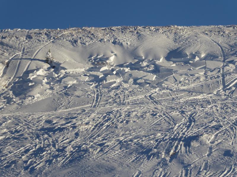 Sled triggered pocket on Saturday