| Please join us at the 23rd annual Black Diamond Fall Fundraiser Party Thursday Sept 15. Tickets are on sale now here, at the Black Diamond store & at REI. Special bonus raffle for online ticket purchasers! |
| Please join us at the 23rd annual Black Diamond Fall Fundraiser Party Thursday Sept 15. Tickets are on sale now here, at the Black Diamond store & at REI. Special bonus raffle for online ticket purchasers! |
| Advisory: Skyline Area Mountains | Issued by Brett Kobernik for Saturday - January 2, 2016 - 7:22am |
|---|

|
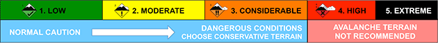
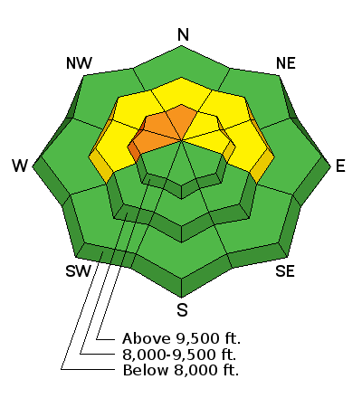
bottom line The majority of the terrain in the mountains has a LOW to MODERATE avalanche danger. A CONSIDERABLE avalanche danger exists along the higher ridges on steep slopes that face west, northwest and north where the recent wind has transported snow and formed large fresh drifts. There may be a few slopes in the higher terrain which did not avalanche during last week's natural avalanche cycle which may still be triggered today by a person. Use caution in the higher terrain today.
|
 |
special announcement We've been experiencing problems with our website over the last few days. The problem lies within the company who hosts our virtual server. Linode is the company and they are doing everything they can to restore web services. |
 |
current conditions East wind on Friday blew harder than anticipated and moved lots of snow in the higher terrain. The wind has slowed dramatically at this time. Temperatures are warmer this morning with most stations in the upper teens. |
 |
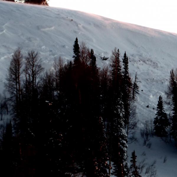
recent activity The wind transported snow created some avalanche activity on Friday. It was on west, northwest and north facing slopes that had gotten wind loaded. Most of the activity I saw was minimal but I wouldn't be surprised to find a bigger avalanche from that wind loading event. Below: small natural avalanche from east wind loading the slope
|
| type | aspect/elevation | characteristics |
|---|

|
|
LIKELIHOOD
 LIKELY
UNLIKELY
SIZE
 LARGE
SMALL
TREND
 INCREASING DANGER
SAME
DECREASING DANGER
|
|
description
The most dangerous situation out there today is if you were to find an area which did not avalanche during last week's natural avalanche cycle AND has been recently loaded up with drifted snow from Friday's wind. This could result in a deep and dangerous avalanche. This type of slope that may avalanche today will be a bit elusive but don't let your guard down. |
 |
weather We'll see mostly cloudy skies today with temperatures getting up to around 20˚F or maybe slightly warmer. The wind will continue to shift to the south and then southwest and will be light to moderate in speed. Sunday looks similar with warmer temperatures. A number of storms are shaping up for next week which may give us some more snow. As of now it looks like there will be impulses on Tuesday, Wednesday and Friday. I'll give more details on these in Sunday's advisory. |
| general announcements We will publish full detailed advisories Saturday and Sunday mornings by 7am. We will also be publishing basic avalanche danger ratings & info during the week. If you are getting out into the mountains, we love to hear from you! You can SUBMIT OBSERVATIONS ONLINE or EMAIL US If you would like to have avalanche advisories emailed to you, SIGN UP HERE We can provide basic avalanche awareness presentations for your school, group or club. To enquire, CLICK HERE |