

| Advisory: Skyline Area Mountains | Issued by Brett Kobernik for February 23, 2013 - 6:19am |
|---|


Above treeline
Near treeline
Below treeline
|
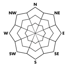
bottom line The avalanche danger will be on the rise today and Sunday. There will be a CONSIDERABLE avalanche danger. The steep easterly facing bowls should be avoided. Areas with a thinner weaker snowpack that face west through north through east which receive new snow especially if deposited by wind should be avoided.
|
 |
current conditions The Manti Skyline picked up 4 to 8 inches of new low density snow on Thursday night improving the riding conditions greatly. This may change with anticipated winds today which are now starting to increase from the southwest. Temperatures are in the teens. Here is a great observation talking about the current snowpack around Ephraim Canyon from Steve and Darce: DETAILS |
 |
recent activity There were a handful of avalanches reported from last weekend that broke into older weak snow that formed during January and is now buried. These occurred in thinner snowpack areas. Ephraim Canyon: DETAILS Photo: Cade Beck.
Seeley Canyon: DETAILS Photo: Darce Trotter
|
| type | aspect/elevation | characteristics |
|---|
 |


Above treeline
Near treeline
Below treeline
|
|
|
description
With lots of loose low density snow around and with more snowfall expected today, the winds should easily be able to transport snow into fresh drifts that will be sensitive. It's not the day for climbing the big bowls as they will be getting loaded with snow. |
| type | aspect/elevation | characteristics |
|---|
 |


Above treeline
Near treeline
Below treeline
|
|
|
description
The more dangerous type of avalanche that could occur today is one that breaks into older weak sugary snow that is buried deeper in the snowpack. More shallow locations are the more suspect where the snow depth is 3 feet or less. Pay attention if your track is sinking through to 'sugary' snow indicating that you're in a more shallow and weak snowpack area. Stopping and getting off to probe or dig is a great way to find these sugary grains. |
 |
weather We'll see snow and areas of blowing snow today with a high near 22. Temperatures will drop through the day as a cold front moves through. Wind chill values will be as low as -2. It will be blustery, with a west southwest wind 11 to 16 mph becoming west northwest 20 to 25 mph in the afternoon. Winds could gust as high as 39 mph. We should see snow accumulation of 5 to 9 inches possible. It will remain cold on Sunday with the chance of snow but not much accumulation expected. |
| general annoucements Remember your information can save lives. If you see anything we should know about, please participate in the creation of our own community avalanche advisory by submitting snow and avalanche conditions. You can call me directly at 801-231-2170, email craig@utahavalanchecenter.org, or email by clicking HERE This is a great time of year to schedule a free avalanche awareness presentation for your group or club. You can contact me at 801-231-2170 or email craig@utahavalanchecenter.org Donate to your favorite non-profit –The Friends of the Utah Avalanche Center. The UAC depends on contributions from users like you to support our work. The information in this advisory is from the US Forest Service which is solely responsible for its content. This advisory describes general avalanche conditions and local variations always occur. This advisory will be updated by 7:00 AM Saturday, March 2nd. |