

Avalanche Advisory
| Advisory: Skyline Area Mountains | Issued by Craig Gordon for January 30, 2013 - 7:00am |
|---|


 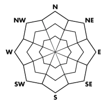
Above treeline
Near treeline
Below treeline
|
bottom line At and above treeline the avalanche danger is CONSIDERABLE today and human triggered slides are likely on steep wind drifted slopes. Within this terrain, especially the closer you travel towards I-70 on the southern half of the range, pockets of HIGH avalanche danger exist and dangerous human triggered slides are very likely. A MODERATE avalanche danger is found on upper elevation south facing terrain and human triggered avalanches are possible on steep, wind drifted slopes. LOW avalanche danger is found in wind sheltered terrain where there are no steep slopes above or adjacent to where you're riding .
|
 |
special avalanche bulletin Strong winds will continue overloading our preexisting snowpack, leading to deceptively tricky avalanche conditions. Deep, dangerous human triggered avalanches are likely, especially on steep wind drifted slopes. |

 |
current conditions Storm totals are hit and miss along the Skyline. While most areas received 6"-8" of new snow since Sunday afternoon, the south half of the range, closer to I-70, got pounded with close to 18" of snow. West and northwest winds have been busy at work, blowing in the 30's and 40's along the ridges and temperatures are in the mid teens. Outstanding riding and turning conditions will be found today, especially in mid elevation wind sheltered terrain. |
 |
recent activity Visibility has been poor and we have no reports of recent avalanche activity.
|
Avalanche Problem 1over the next 24 hours
| type | aspect/elevation | characteristics |
|---|
 |


Above treeline
Near treeline
Below treeline
|
|
|
description
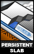
Strong winds have been forming dense cohesive slabs on upper elevation leeward slopes, especially those facing the north half of the compass. Problem is... the snow will feel solid under our skis, board, or sled allowing us to get well out onto the slope before it fails. Unfortunately, today's avalanches can break while we're mid slope and they'll be packing a punch. It doesn't mean you can't ride today. It does mean that you should think about toning slope angles and objectives down a notch and think about the consequences of triggering a slide.
|

Avalanche Problem 2over the next 24 hours
| type | aspect/elevation | characteristics |
|---|
 |


Above treeline
Near treeline
Below treeline
|
|
|
description
Fresh wind slabs are the most obvious avalanche problem today and they're the most manageable, but don't get tricked into thinking this is the only avalanche dragon out there. An easily triggered soft slab can quickly get out of hand, especially if it breaks into weaker layers of the snowpack as it crashes down on the slope below. |
 |
weather A moist northwest flow camps out over the region today through tomorrow, bringing another round of snow and wind with 4" of snow expected by tonight. West winds are gonna be a nuisance, blowing 15-30 mph with higher gusts possible. Temperatures climb into the mid 20's before dipping into the low teens overnight. Mostly cloudy skies are expected on Thursday, before high pressure builds for the latter portion of the week. |
| general annoucements Remember your information can save lives. If you see anything we should know about, please participate in the creation of our own community avalanche advisory by submitting snow and avalanche conditions. You can call me directly at 801-231-2170, email craig@utahavalanchecenter.org, or email by clicking HERE This is a great time of year to schedule a free avalanche awareness presentation for your group or club. You can contact me at 801-231-2170 or email craig@utahavalanchecenter.org Donate to your favorite non-profit –The Friends of the Utah Avalanche Center. The UAC depends on contributions from users like you to support our work. The information in this advisory is from the US Forest Service which is solely responsible for its content. This advisory describes general avalanche conditions and local variations always occur. This advisory will be updated by 7:00 AM Saturday February 2nd. |