

Avalanche Advisory
| Advisory: Skyline Area Mountains | Issued by Brett Kobernik for January 19, 2013 - 5:47am |
|---|


Above treeline
Near treeline
Below treeline
|
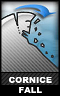
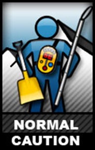
bottom line There is an overall LOW avalanche danger in most of the terrain along the Manti Skyline. Stay off of large cornices along the upper ridges and avoid areas that look like they contain a large and recent drift of wind blown snow.
|

 |
current conditions We have mostly clear skies with temperatures in the mid 20s and light west winds. There is extensive wind damage at all elevations due to a wind event that happened earlier in the week. This has scoured the snow surface and created some large drifts and cornices. |
 |
recent activity There was no recent avalanche activity that I could see during my field day on Thursday but we did come across an avalanche that had released naturally during the Christmas snow storm. DETAILS |
Avalanche Problem 1over the next 24 hours
| type | aspect/elevation | characteristics |
|---|
 |
Above treeline
Near treeline
Below treeline
|
|
|
description
It is important to always avoid the large cornices that form along the upper ridges of the Skyline. Cornices often break back much further than anticipated. Approach ridges with caution because it is easy to not realize that you are getting onto a cornice until it's too late. |

Avalanche Problem 2over the next 24 hours
| type | aspect/elevation | characteristics |
|---|
 |


Above treeline
Near treeline
Below treeline
|
|
|
description
The snowpack is mostly stable at this time in the Skyline region. Always follow safe backcountry procedures by only putting one person on a slope at a time and always stay out from under avalanche paths. Avoid the larger "pillowy" looking drifts of snow which seem to be welded in place but may still pop loose. |

 |
weather High pressure is the dominant weather pattern over the weekend and into next week. This will produce mild temperatures, mostly clear skies and light winds. Ridgetop temperatures will get into the mid 30s to around 40 this weekend. Some sort of a change in the weather pattern looks like it will take place later next week with a storm starting to shape up. |
| general annoucements Remember your information can save lives. If you see anything we should know about, please participate in the creation of our own community avalanche advisory by submitting snow and avalanche conditions. You can call Craig Gordon directly at 801-231-2170, email craig@utahavalanchecenter.org, or email by clicking HERE This is a great time of year to schedule a free avalanche awareness presentation for your group or club. You can contact me at 801-231-2170 or email craig@utahavalanchecenter.org Donate to your favorite non-profit –The Friends of the Utah Avalanche Center. The UAC depends on contributions from users like you to support our work. The information in this advisory is from the US Forest Service which is solely responsible for its content. This advisory describes general avalanche conditions and local variations always occur. The advisory expires 24 hours after the date and time posted, but will be updated by 7:00 AM Saturday Jan. 19, 2013 |