

Avalanche Advisory
| Advisory: Skyline Area Mountains | Issued by Brett Kobernik for December 29, 2012 - 6:58am |
|---|


 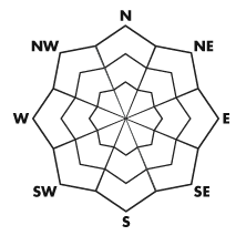
Above treeline
Near treeline
Below treeline
|
bottom line There is a CONSIDERABLE avalanche danger on steep slopes that face northwest through north through east in the mid and upper elevations. It is no time to be getting into the steeper terrain. The snowpack should stabilize a lot more in a few days.
|

 |
special announcement Please join us on Thursday evening, 1/24 and Saturday, 1/26 for a day of learning avalanche and advanced riding skills with Craig & Trent from the Utah Avalanche Center and Dan Gardiner and the Boondockers crew. Details and sign up here
The advisory expires 24 hours after the date and time posted, but will be updated by 7:00 AM Saturday Jan. 5, 2013 |
 |
current conditions WOW!! The Manti Skyline got POUNDED by the last snow storm adding 2 to 3 feet of new snow! This has dramatically changed the landscape making much more terrain available. However, it is so deep that this limits travel. It will take a few days before the snow settles enough to be able to get into the normal drainages. It's pretty cold with temps in the upper single digits and low teens. Winds are from the southwest with fairly light speeds. |
 |
recent activity Visibility was quite poor on Friday for most of the day but it did start to lift a bit later in the afternoon. This revealed some natural avalanche activity (Avalanche on GE Hill) but from what I could see up in Lake Canyon, Rolfson and Staker, there was not a widespread natural avalanche cycle. I very much like to see this but this doesn't mean it's green light conditions. It's best to let the snowpack settle and adjust for a couple of days before getting into the bigger terrain. This won't be a problem since the very deep new snow limits travel anyway. |
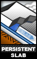
Avalanche Problem 1over the next 24 hours
| type | aspect/elevation | characteristics |
|---|
 |
Above treeline
Near treeline
Below treeline
|
|
|
description
By far, the most dangerous thing would be to trigger an avalanche that breaks into old weak snow that's been around since November. This would include over 3 feet of snow and could fracture quite wide. Let the snowpack settle for a couple of days before getting onto any large steep slope that faces northwest through north through east. |

Avalanche Problem 2over the next 24 hours
| type | aspect/elevation | characteristics |
|---|
 |
Above treeline
Near treeline
Below treeline
|
|
|
description
The wind has transported enough snow to make just fresh wind slabs an issue. Avoid any steep slopes where you see obvious wind 'pillows' or deep textured snow. With a slight increase with southwesterly wind today, I'd expect a bunch of the newest low density snow to get blown around quite easily into dangerous drifts. |

 |
weather It's going to be a very nice day today with mostly sunny skies and temperatures getting up around 20. Southwest winds will pick up into the moderate speed category. A storm will move through to our south on Sunday and cloud things up in our area with the chance of snow showers lingering into Monday with continued colder temperatures. Not much accumulation is expected with this storm. Things clear out again on New Year's Day through into next weekend. Our long term weather pattern doesn't look especially active and I'm not seeing much chance for snow for quite a while. |
| general annoucements Remember your information can save lives. If you see anything we should know about, please participate in the creation of our own community avalanche advisory by submitting snow and avalanche conditions. You can call Craig Gordon directly at 801-231-2170, email craig@utahavalanchecenter.org, or email by clicking HERE This is a great time of year to schedule a free avalanche awareness presentation for your group or club. You can contact me at 801-231-2170 or email craig@utahavalanchecenter.org Donate to your favorite non-profit –The Friends of the Utah Avalanche Center. The UAC depends on contributions from users like you to support our work. The information in this advisory is from the US Forest Service which is solely responsible for its content. This advisory describes general avalanche conditions and local variations always occur. The advisory expires 24 hours after the date and time posted, but will be updated by 7:00 AM Saturday Jan. 5, 2013 |