| During the month of April, Mark Miller will donate $75 to the charity of your choice (5 to chose from, including the Utah Avalanche Center!) Mark Miller Subaru has raised over $300k in the previous 6 Do Good Feel Good events. More Info here |  |

For every car Mark MIller Subaru sells in April, they will donate $75 to the charity of your choice (5 to choose from). Who are you going to choose? Plus - you can vote for your favorite and the 3 groups receiving the most votes get an additional cash prize donated by Mark Miller Subaru. Details here

| During the month of April, Mark Miller will donate $75 to the charity of your choice (5 to chose from, including the Utah Avalanche Center!) Mark Miller Subaru has raised over $300k in the previous 6 Do Good Feel Good events. More Info here |  |
| Advisory: Salt Lake Area Mountains | Issued by Evelyn Lees for Tuesday - February 24, 2015 - 6:33am |
|---|
 |
special announcement The 2015 Wasatch Splitfest kicks off this Thursday night, February 26th at 7 PM, with a Presentation/Raffle night at Brewvies Cinema Pub. Come join us for a social evening of food, drinks, presentations of splitboarding adventures from around the world, and a chance to win gear from Chimera, Voile, Arc'teryx, Patagonia, and many others. All proceeds from the raffle go directly to support the Utah Avalanche Center. The splitfest will continue through the weekend with tour meetups, clinics, demo gear, and more. This is a grassroots event to gather the backcountry snowboarding tribe, with an emphasis on safety, education, and fun. All are welcome. Check out http://www.facebook.com/WasatchSplitfest for all the details. |
 |
current conditions It’s refreshingly cool this morning, with mountain temperatures in the teens and low 20s. The northeasterly winds have decreased, with most stations averaging in the 5 to 10 mph range. Across the highest terrain, average speeds are 15 to 20 mph. Wind sheltered, shady slopes have excellent powder, especially in the upper Cottonwoods, which received the most snow from the last storm. Other aspects will be sun crusted this morning, a mix of breakable and hard and icy, though most should soften later today. Small hard wind drifts are scattered about the mid and upper elevations, ready to trip you up. |
 |
recent activity Numerous small harder wind slabs, 2 to 10” deep and up to 30’ wide, were purposely triggered from the Mill Creek ridge line south through Little Cottonwood Canyon, with one remotely triggered. As the day heated, it was possible to push a few wet loose sluffs into motion in the Provo area mountains. Remotely triggered wind slab, White Pine About 8" deep by 30' wide. (Schmookler photo)
|
| type | aspect/elevation | characteristics |
|---|


|


|

LIKELIHOOD
 LIKELY
UNLIKELY
SIZE
 LARGE
SMALL
TREND
 INCREASING DANGER
SAME
DECREASING DANGER
|
|
description
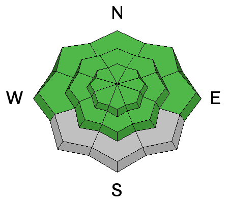
There are two avalanches issue today, both of which can be mitigated by sharp observation, terrain choices and timing. The cracky, hard wind drifts scattered about will still be sensitive today. They are just large enough to grab a person on foot, skies or a board and take them for a ride in steep terrain, while of little consequence to a snowmobiler. They are only an issue if you are caught on a slope with bad consequences where you could go for a long ride, off a cliff or into rocks. Take the time to recognize what these drifts look and feel like. They are most widespread along the ridgelines and on slopes with a westerly aspect, though I was also finding them well down into open bowls and along sub ridges. With warmer temperatures and less wind today, wet loose sluffs will become active as the snow heats. Most will need a push, but a few naturals are possible in steepest terrain that received the most snow. Avoiding travel on and below steep sunny slopes as the snow heats up (east through south through west). Example of wind drifted terrain, Mill Creek ridge line (Kikkert photo)
|
 |
weather It will be another beautiful day - sunny, with temperatures warming to near 30 at 8,000’ and into the mid 20s at 10,000’. The northeasterly winds will be generally light, with occasional gusts in the 30s across the highest terrain. Slightly cooler with a few scattered clouds on Wednesday and the flow turns to the northwest. The next chance for a little snow will be Thursday afternoon into Friday. The Saturday storm may head south like the last one. |
general announcements
|
Advisory Hotline: (888) 999-4019 | Contact Information