| During the month of April, Mark Miller will donate $75 to the charity of your choice (5 to chose from, including the Utah Avalanche Center!) Mark Miller Subaru has raised over $300k in the previous 6 Do Good Feel Good events. More Info here |  |

For every car Mark MIller Subaru sells in April, they will donate $75 to the charity of your choice (5 to choose from). Who are you going to choose? Plus - you can vote for your favorite and the 3 groups receiving the most votes get an additional cash prize donated by Mark Miller Subaru. Details here

| During the month of April, Mark Miller will donate $75 to the charity of your choice (5 to chose from, including the Utah Avalanche Center!) Mark Miller Subaru has raised over $300k in the previous 6 Do Good Feel Good events. More Info here |  |
| Advisory: Salt Lake Area Mountains | Issued by Brett Kobernik for Tuesday - November 19, 2013 - 7:24am |
|---|
 |
current conditions Mild weather started on Sunday and continued through Monday with ridgetop highs near 40 or better. Southwest winds picked up in speed starting late yesterday afternoon with some strong gusts overnight and are blowing in the moderate range now. Temperatures remained very mild overnight but are decreasing now and are around 30 along the ridges. |
 |
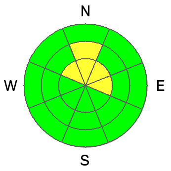
recent activity Reports of avalanches over the weekend continue to slowly trickle in with some evidence of some natural activity from during the storm (Naturals in Cascade) as well as the most recent report of an avalanche on north facing Davenport Hill in Silver Fork of Big Cottonwood Canyon. (DETAILS) It fits the pattern to a tee with our buried weak layers and other recent avalanches on those layers. Upper elevation north facing aspects remain suspect. CLICK HERE for a snow and weather summary for the first half of November. |
| type | aspect/elevation | characteristics |
|---|


|


|

LIKELIHOOD
 LIKELY
UNLIKELY
SIZE
 LARGE
SMALL
TREND
 INCREASING DANGER
SAME
DECREASING DANGER
|
|
description
As time goes on, triggering an avalanche on these high north slopes becomes less of a chance. However, don't be surprised if you go up there and trigger something. The problem is we want to go to the places where we are most likely to trigger an avalanche because these same places hold the most snow, and snow cover is scarce right now. |
| type | aspect/elevation | characteristics |
|---|


|


|

LIKELIHOOD
 LIKELY
UNLIKELY
SIZE
 LARGE
SMALL
TREND
 INCREASING DANGER
SAME
DECREASING DANGER
|
|
description
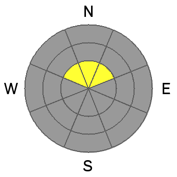
With the warm temperatures on Monday making the southerly slopes become damp, there's probably not much snow available for transport but with some wind overnight, this avalanche problem is at least worth a mention. |
 |
weather A westerly flow could bring us some snow over the next couple of days with a closed |
| general announcements If you trigger an avalanche in the backcountry - especially if you are adjacent to a ski area – please call the following teams to alert them to the slide and whether anyone is missing or not. Rescue teams can be exposed to significant hazard when responding to avalanches, and do not want to do so when unneeded. Thanks. Salt Lake and Park City – Alta Central (801-742-2033), Canyons Resort Dispatch (435-615-3322) Twitter Updates for your mobile phone - DETAILS UDOT canyon closures UDOT at (801) 975-4838 Get your advisory on your iPhone with the Utah Avalanche Center mobile app, along with great navigation and rescue tools. Remember your information can save lives. If you see anything we should know about, please participate in the creation of our own community avalanche advisory by submitting snow and avalanche conditions. You can also call us at 801-524-5304 or 800-662-4140, email by clicking HERE, or include #utavy in your tweet or Instagram. |
Advisory Hotline: (888) 999-4019 | Contact Information