

| Advisory: Salt Lake Area Mountains | Issued by Brett Kobernik for March 26, 2013 - 7:05am |
|---|


Above 9,500 ft.
8,000-9,500 ft.
Below 8,000 ft.
|
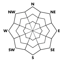
bottom line The avalanche danger will most likely stay in the MODERATE category but may rise to CONSIDERABLE due to warming temperatures. As the snow becomes damp and crusts soften, this is your cue that it's time to start considering your exit from avalanche terrain. TAKE CAUTION DURING ANY PERIOD OF DIRECT SUN AND BE WILLING TO CHANGE YOUR OBJECTIVE!!
|
 |
current conditions The cold powder of the last storm is a thing of the past. Check out my review of the last 6 days HERE. Temperatures increased overnight by around 5 degrees at most locations with readings around 30 along the 9000 foot ridgelines. Winds are light mainly from the southwest. We have partly cloudy skies. |
 |
recent activity There was one significant avalanche incident that occurred on Monday where a skier triggered a soft slab which caught and carried him about 1700 vertical feet down the southeast face of Mt Superior in Little Cottonwood Canyon. He was partially buried and sustained a dislocated shoulder and was able to get down with assistance from his partners. The avalanche involved the newest snow which was warming with daytime heating. DETAILS |
| type | aspect/elevation | characteristics |
|---|
 |


Above 9,500 ft.
8,000-9,500 ft.
Below 8,000 ft.
|
|
|
description
The new snow becoming unstable due to daytime heating is your main concern again today. Stay out of steep confined gullies today as natural avalanches may flush down them. Get off of southerly facing slopes first. Consider where you will be later in the day making sure you don't get trapped on or below steep avalanche paths when you exit. Choose terrain where you have a safe exit route if things become too damp. |
 |
weather The sun will be somewhat filtered by clouds this morning with, MOST LIKELY, more clouds moving as the day progresses along with the slight chance for a snow flurry. Temperatures will be around 8 degrees warmer than Monday with ridgetop highs in the mid 30s and 8000 foot highs in the mid 40s. Ridgetop winds will be light from the southwest. We'll have warmer temperatures once again on Wednesday and should remain mild for the remainder of the week. |
| general annoucements Go to http://www.backcountry.com/utah-avalanche-center to get EVEN MORE DISCOUNTED tickets from our partners at Beaver Mountain and Sundance. All proceeds benefit the Utah Avalanche Center. If you trigger an avalanche in the backcountry - especially if you are adjacent to a ski area – please call the following teams to alert them to the slide and whether anyone is missing or not. Rescue teams can be exposed to significant hazard when responding to avalanches, and do not want to do so when unneeded. Thanks. Salt Lake and Park City – Alta Central (801-742-2033), Canyons Resort Dispatch (435-615-3322) Ogden – Snowbasin Patrol Dispatch (801-620-1017) Powder Mountain Ski Patrol Dispatch (801-745-3772 ex 123) Provo – Sundance Patrol Dispatch (801-223-4150) Dawn Patrol Forecast Hotline, updated by 05:30: 888-999-4019 option 8. Twitter Updates for your mobile phone - DETAILS Daily observations are frequently posted by 10 pm each evening. Subscribe to the daily avalanche advisory e-mail click HERE. UDOT canyon closures UDOT at (801) 975-4838 Wasatch Powderbird Guides does daily updates about where they'll be operating on this blog http://powderbird.blogspot.com/ . Remember your information can save lives. If you see anything we should know about, please participate in the creation of our own community avalanche advisory by submitting snow and avalanche conditions. You can also call us at 801-524-5304 or 800-662-4140, email by clicking HERE, or include #utavy in your tweet. Donate to your favorite non-profit –The Friends of the Utah Avalanche Center. The UAC depends on contributions from users like you to support our work. For a print version of this advisory click HERE. This advisory is produced by the U.S. Forest Service, which is solely responsible for its content. It describes only general avalanche conditions and local variations always exist. Specific terrain and route finding decisions should always be based on skills learned in a field-based avalanche class. |