SPECIAL ANNOUNCEMENT |
 |
We are doing intermittent avalanche advisories, and this forecast will cover April 26-29. Avalanche advisories will end for the season after the weekend.
Alta Ski Area will be closed to uphill traffic for the next couple weeks. However, you can still go up the summer road towards Catherine's Pass. |
|
|
BOTTOM LINE
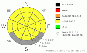
Danger by aspect and elevation on slopes approaching 35° or steeper.
(click HERE for tomorrow's danger rating)
|

Danger Rose Tutorial
|
Watch for new snow avalanches during the storm Thursday night and Friday such as soft slabs within the new snow and wind slabs. After the storm when the sun comes out, watch for wet sluffs on steep, sun exposed slopes. |
|
|
CURRENT CONDITIONS |

|
Temperatures have thankfully cooled down from the sweltering, hot weather earlier in the week. |
|
|
RECENT ACTIVITY |

|
Since temperatures significantly cooled over the past couple days, wet avalanche activity seems to have subsided as well. There was a number of large, deep, wet slabs that released early in the week on the upper elevation, north facing slopes. |
|
|
THREAT #1 |

|
| WHERE |
PROBABILITY |
SIZE |
TREND |

|
|
|
|
|
|
We have returned to a much more predictable springtime pattern.
6-12 inches of snow are forecast for Thursday night into Friday. So you should practice your usual bag of tricks with storm snow, jump on small test slopes to see how they respond, dig down with your hand to see how well it's bonded, and most importantly, avoid any steep slope with recent deposits of wind drifted snow.
Then after the snow storm, when the sun hits the slope, you should expect the usual round of damp or wet sluffs on steep slopes. It's not exactly rocket science but just common snow sense. |
|
|
MOUNTAIN WEATHER |

|
8-12 inches of new snow is forecast for Thursday night into Friday. The snow/rain line should start out around 9,000' and drop to around 5,000' on Friday. Lightning is possible and as usual with spring storms, convective activity can create widely variable snow amounts from one place to another.
For the weekend, we should have partly cloudy skies with lows just below freezing and the daytime highs in the mid 40's |
|
|
GENERAL ANNOUNCEMENTS |
If you're getting out and see anything I should know about, please let me know. You can leave a message on our answering machine at 800-662-4140 or fill out the observation form on our home page at www.UtahAvalancheCenter.org.
Although I will most likely not update the advisory over the weekend, I will post any observations posted from our home page. |
|
|
This information does not apply to developed ski areas or highways where avalanche control is normally done. This advisory is from the U.S.D.A. Forest Service, which is solely responsible for its content. This advisory describes general avalanche conditions and local variations always occur. |
|
This advisory provided by the USDA Forest Service, in partnership with:
The Friends of the Utah Avalanche Center, Utah Division of State Parks and Recreation, Utah Division of Emergency Management, Salt Lake County, Salt Lake Unified Fire Authority and the friends of the La Sal Avalanche Center. See our Sponsors Page for a complete list. |


