SPECIAL ANNOUNCEMENT |
 |
Unopened ski resorts must be treated as backcountry terrain. There is no avalanche control work being done nor is there ski patrol available for injuries or rescue until the resorts open for the season. You are responsible for your actions in these areas. Treat them as any other backcountry terrain, which includes not traveling above other parties in steep terrain. |
|
|
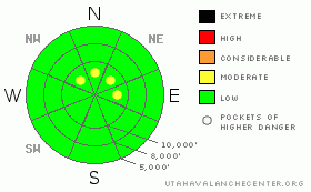
BOTTOM LINE
Danger by aspect and elevation on slopes approaching 35° or steeper.
(click HERE for tomorrow's danger rating)
|

Danger Rose Tutorial
|
The avalanche danger is generally LOW. But there may be pockets of MODERATE danger on any steep slope with recent wind drifts or on very steep slopes from sluffing new snow. |
|
|
CURRENT CONDITIONS |

|
Only an inch of new snow has fallen so far this morning but we're only expecting less than 6 inches for the rest of the day. Ridge top winds have remained reasonable from the west and northwest at around 10 mph. Ridge top temperatures are fairly warm, in the mid 20's.
The 3-4 feet of new snow that fell mid week has settled to about half that amount. The most snow fell in the upper portion of Little Cottonwood Canyon from strong lake effect snowfall and less snow fell in Big Cottonwood Canyon, where the upper elevation north facing slopes only have about a foot of settled snow and a couple feet of settled snow on the north facing slopes in Little Cottonwood Canyon. But the snow is dense and forms a great early season base. Outside of the Salt Lake area mountains, there isn't enough snow for much recreation unless you are a hunter or hiker. |
|
|
RECENT ACTIVITY |

|
There was no avalanche activity reported from Saturday. (It's very early in the season and our overachieving Brett Kobernik has compiled a few early season reminders that you may want to take a look at to get you thinking snow again. Click HERE) |
|
|
THREAT #1 |

|
| WHERE |
PROBABILITY |
SIZE |
TREND |

|
|
|
|
| |
|
|
Over the next
24
hours.
|
|
|
The old snow is quite stable and if the forecast verifies, I don't think that the 5 inches of new snow we are expecting today will change avalanche conditions very much. It's warm and the winds are light, so in theory, the new snow should bond well to the old snow surface. There is a little bit of fine-grained, faceted snow that has formed on the upper elevation shady slopes but with the small amount of new snow forecast, it should not be a player, but we should keep an eye on it for future storms.
Today, if the wind picks up (but it's not forecasted) it may drift snow onto downwind terrain, so as always, you should avoid any steep slopes with recent wind deposits. Also, watch out for sluffs of new snow on very steep terrain that may take you into the plentiful rocks or stumps this time of year. |
|
|
MOUNTAIN WEATHER |

|
Today we should be mostly cloudy with light snow showers all day. Accumulations should remain under 6 inches. Ridge top winds should blow 5-15 mph from the west and northwest with ridge top temperatures around 30 today and the overnight low in the lower 20's. Snow showers should taper off tonight with just another inch or so. Tuesday should remain cloudy to partly cloudy with a slight chance of snow. You can see more details in the graphical forecast.
The rest of the week looks cloudy and warm with light snow showers but, unfortunately, we don't expect any significant accumulations.
|
|
|
GENERAL ANNOUNCEMENTS |
As you notice, we are still getting the bugs worked out of our new web site and we hope to have everything working fine and looking spiffier by Thanksgiving. We are still looking for funding to finish the project this winter if you care to donate to the cause.
Our statewide toll free line is 1-888-999-4019 (early morning, option 8).
If you’re getting out and see anything we should know about please let us know. You can leave a message at (801) 524-5304 or 1-800-662-4140, or fill out the observation form on the home page or email us at uac@utahavalanchecenter.org. (Fax 801-524-6301)
Drew Hardesty will update this forecast tomorrow, and thanks for calling. |
|
|
This information does not apply to developed ski areas or highways where avalanche control is normally done. This advisory is from the U.S.D.A. Forest Service, which is solely responsible for its content. This advisory describes general avalanche conditions and local variations always occur. |
|
This advisory provided by the USDA Forest Service, in partnership with:
The Friends of the Utah Avalanche Center, Utah Division of State Parks and Recreation, Utah Division of Emergency Management, Salt Lake County, Salt Lake Unified Fire Authority and the friends of the La Sal Avalanche Center. See our Sponsors Page for a complete list. |


