25th Annual Black Diamond Fall Fundraising Party
Thursday, September 13; 6:00-10:00 PM; Black Diamond Parking Lot

25th Annual Black Diamond Fall Fundraising Party
Thursday, September 13; 6:00-10:00 PM; Black Diamond Parking Lot
| Advisory: Ogden Area Mountains | Issued by Paige Pagnucco for Friday - April 13, 2018 - 5:52am |
|---|
 |
special announcement The last regular early morning forecast will be Sunday, April 15th. |
 |
current conditions Ah....April in Utah! Nothing like living in a place where it can be 60 F in January and then snow a foot when the tulips are blooming. With over a foot of new snow in some Ogden mountain locations, the riding conditions should be pretty good today. Sheltered, lower angle terrain should provide the best opportunity as exposed upper elevation slopes were blasted by strong winds during the storm. Current mountain temperatures are in the mid teens and northwest winds are blowing 10-15 mph, a bit higher on ridgelines. |
 |
recent activity No recent avalanche activity has been reported. |
| type | aspect/elevation | characteristics |
|---|


|


|

LIKELIHOOD
 LIKELY
UNLIKELY
SIZE
 LARGE
SMALL
TREND
 INCREASING DANGER
SAME
DECREASING DANGER
|
|
description
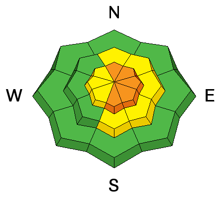
You'll find dangerous avalanche conditions today on some upper elevation, exposed slopes facing the eastern half of the compass. Strong winds and heavy snowfall have built up wind slabs that could still be sensitive to human weight today. These should be isolated to ridgelines and prominent terrain features but it'll still be wise to avoid steep slopes with freshly wind-drifted snow. Remember to look for cracking as a sign of instability. Even though it's mid-April, continue to practice safe travel protocols if you're traveling in or near steep terrain - avalanches have no calendar.
|
| type | aspect/elevation | characteristics |
|---|


|


|

LIKELIHOOD
 LIKELY
UNLIKELY
SIZE
 LARGE
SMALL
TREND
 INCREASING DANGER
SAME
DECREASING DANGER
|
|
description
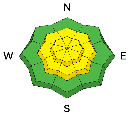
With a decent shot of snow in the past 24 hours, it will be possible to trigger new snow slabs and sluffs in steep upper and mid elevation terrain. Expect any activity to occur within the new snow itself as the storm came in warm and, for the most part, bonded well to the existing surface snow. Test slopes and slope cuts should provide good feedback today. Slope cuts should be done with your speed built up and heading for an island of safety so that, in theory, if the slope does fracture, your momentum will carry you off of the moving slab. Just remember with slope cutting, you're moving diagonally and slightly downhill across the slope, crossing to safety, and moving quickly from one area to the next. If the snow fails on your test slope, it's a good indication to avoid steeper terrain. |
 |
weather Winter in April. It'll be mostly cloudy and quite chilly today as northwesterly winds continue to blow and mountain temperatures stay below freezing. (That bodes well for temporary powder preservation at least.) Though the storm is past we may still pick up an inch or so of snow before the day's end. The weekend looks stellar with abundant sunshine and warming temps. Next chance for precipitation looks to be Monday.
|
| general announcements CLICK HERE FOR MORE GENERAL INFO AND FAQ The UAC has new support programs with Outdoor Research and Darn Tough. Support the UAC through your daily shopping. When you shop at Smith's, or online at Outdoor Research, REI, Backcountry.com, Darn Tough, Patagonia, NRS, Amazon, eBay a portion of your purchase will be donated to the FUAC. See our Donate Page for more details on how you can support the UAC when you shop. Benefit the Utah Avalanche Center when you buy or sell on eBay - set the Utah Avalanche Center as a favorite non-profit in your eBay account here and click on eBay gives when you buy or sell. You can choose to have your seller fees donated to the UAC, which doesn't cost you a penny This information does not apply to developed ski areas or highways where avalanche control is normally done. This advisory is from the U.S.D.A. Forest Service, which is solely responsible for its content. This advisory describes general avalanche conditions and local variations always occur. |